I was born in Peterborough, Ontario, and grew up in nearby Lindsay. Lindsay is a small town of roughly 20,000 people in the Kawartha Lakes region of South-Central Ontario. Prior to 1978, Lindsay served as an important railway terminal, and a key junction for numerous branchlines in Central Ontario. After 1978, traffic and service declined steadily until the eventual abandonment and removal of all tracks by October 1992.
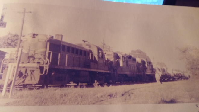
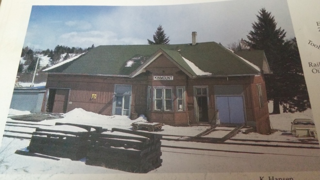
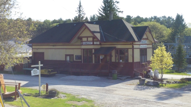
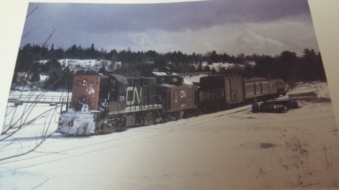
Keith Hansen published the book Last Trains from Lindsay in 1997. This volume brilliantly documents train operations in Lindsay, and helps to display what things were like when trains passed through town. In December 2015, I took advantage of unusually mild weather, and set out to take my own photos at the same locations that Keith did. I returned to the area in April and May of 2016 in order to take additional photos. My intention was to document how these locations have changed and developed over time. Some locations are surprisingly untouched, while others have been completely erased of all signs of railways. I invite you to look at my photos side by side with Keith’s, and compare how things have changed.
NOTE: All “THEN” photos are the work of Keith Hansen and the various other photographers who contributed their work to Last Trains From Lindsay. Credit for those photos go to them, and is provided in each caption. All “NOW” photos were taken by myself between April 2015 and May 2016.
Hansen, K. (1997). Last Trains From Lindsay. Roseneath, Canada: Sandy Flats Publications.
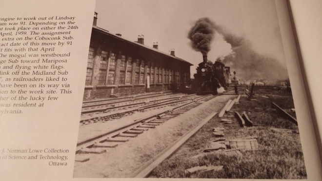
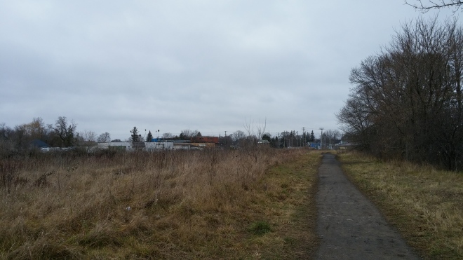
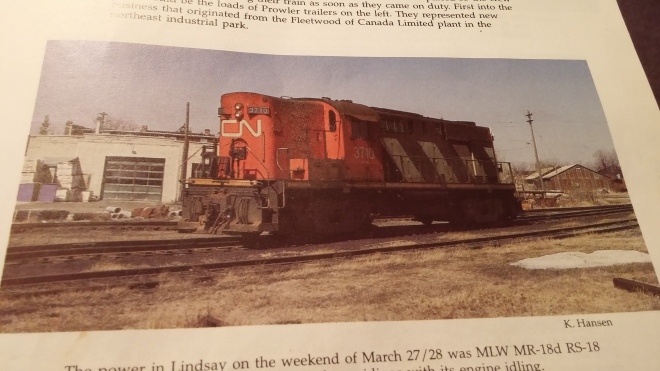
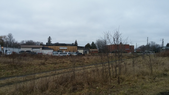
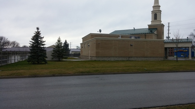
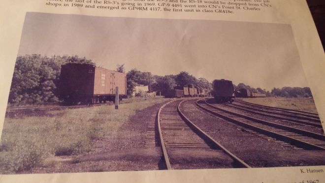
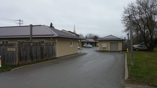
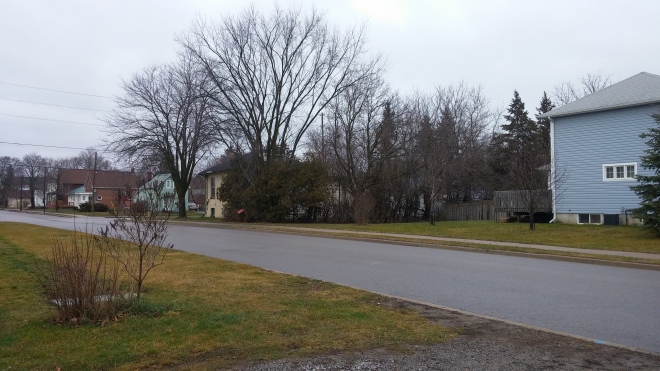
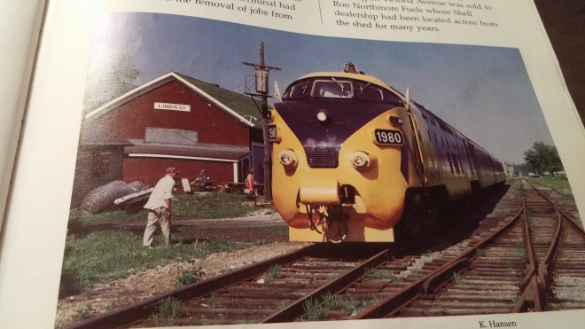
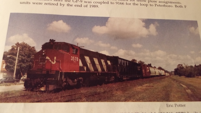
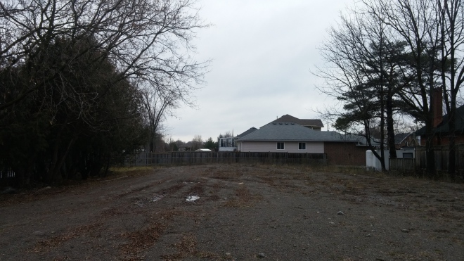
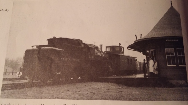
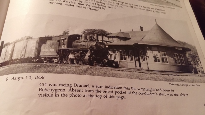
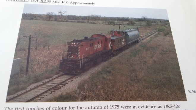
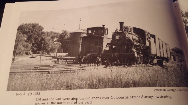
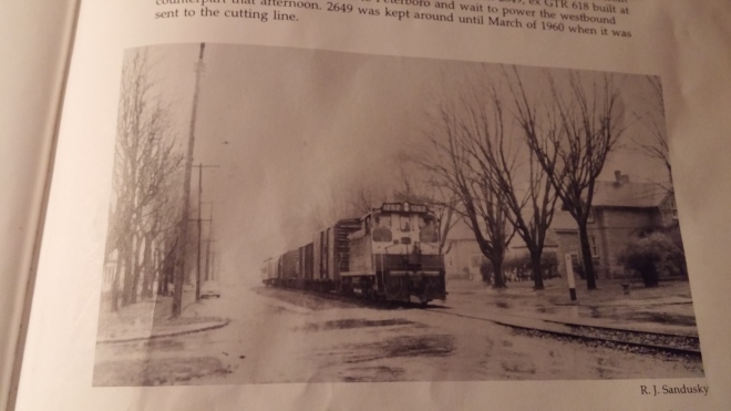
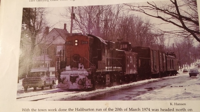
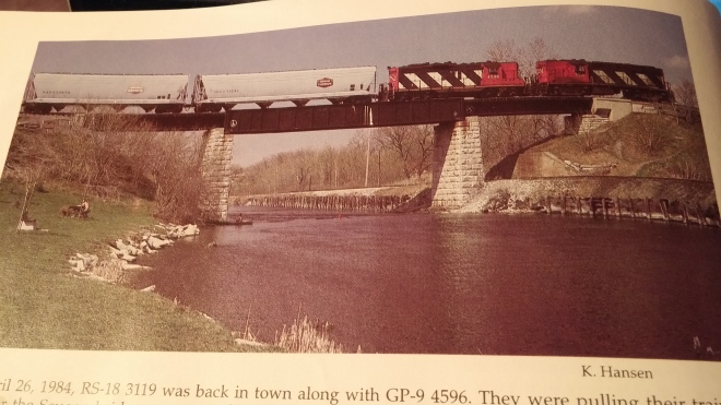
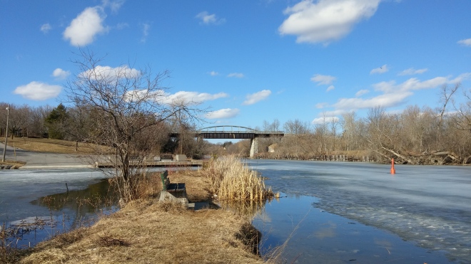
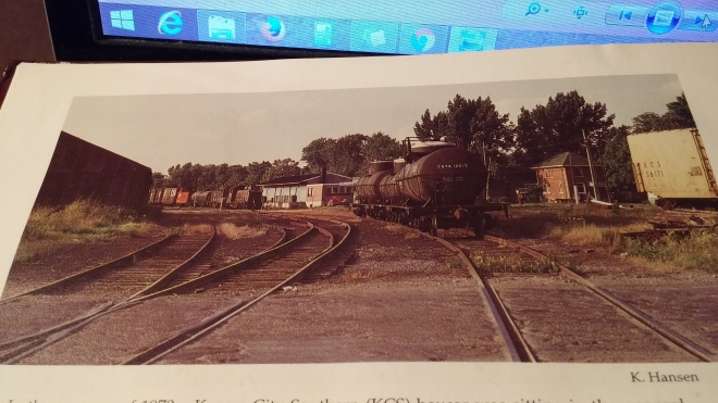
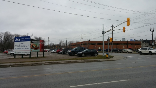
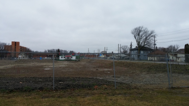
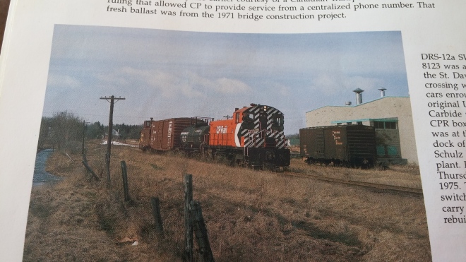
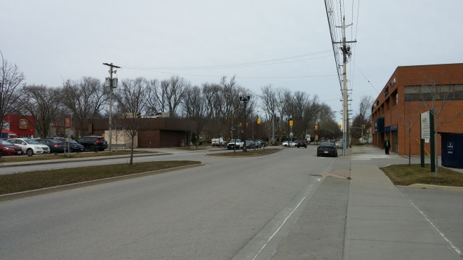
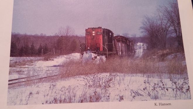
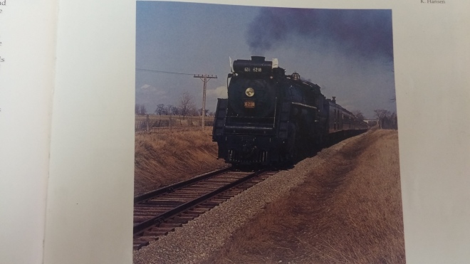
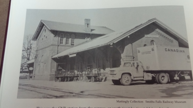
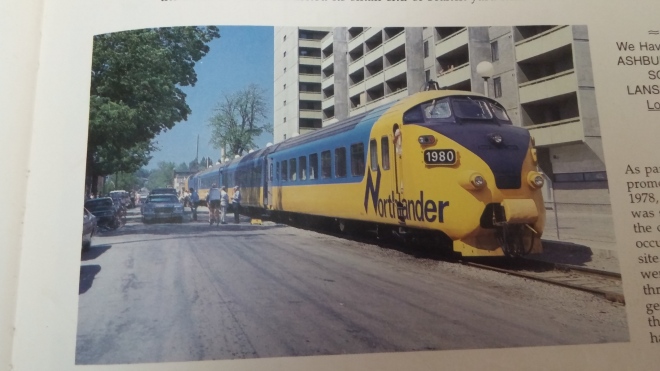
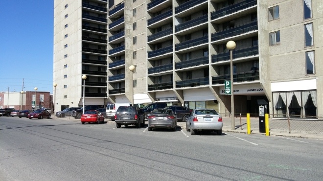
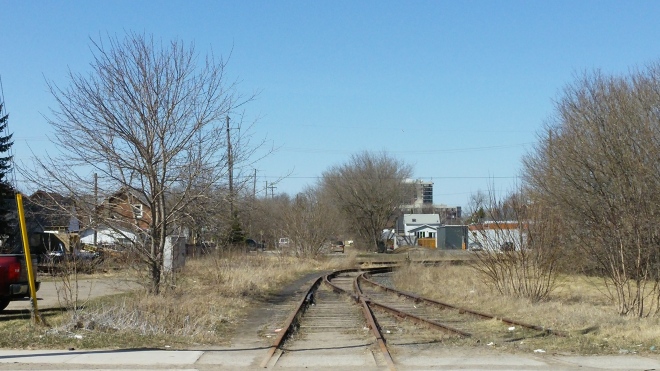
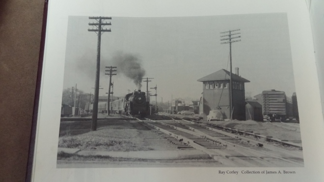
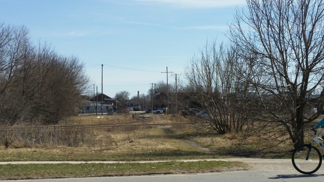
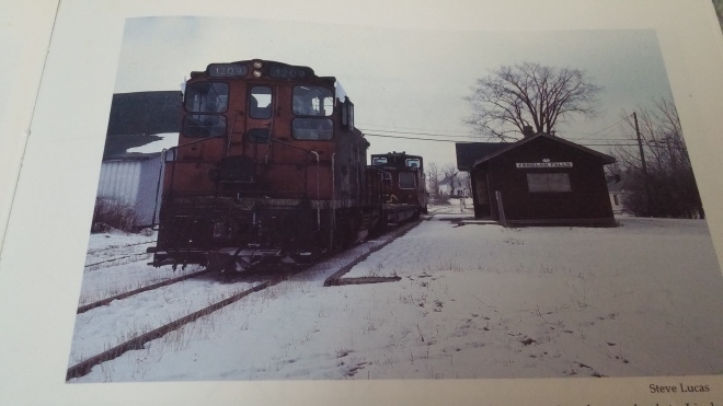
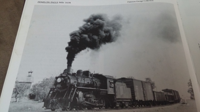
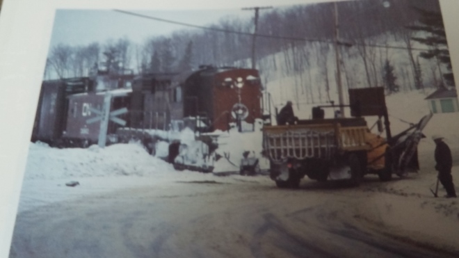
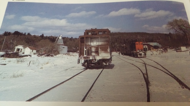
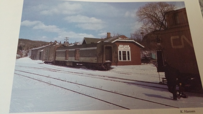
THEN: While steam operations had long since halted, an Upper Canada Railway Society tour brought steam back to Lindsay in April 1970. Canadian National 4-8-4 Northern 6218 reverses around the Lindsay wye towards its train at the station. The wye was a result of the development and arrival of new railways to Lindsay. 6218 is on the east leg of the wye, which was the Midland Railway’s mainline from Midland to Belleville. The west leg brought the Whitby, Port Perry & Lindsay Railway to it’s station, where it met the Victoria and Midland Railways. The south leg was the new extension of the Midland-Belleville mainline, allowing trains to bypass the numerous level crossings on the old route. It also served as a connection between the Campbellford and Uxbridge subdivisions for trains bound for Toronto in later years. Photo taken by Keith Hansen (Hansen, p.41).NOW: A church and a NAPA auto parts sit on what was the eastern leg of the wye. The vacant area in front is the location where the east and west legs of the wye met at what was Victoria Avenue yard. Picture taken looking north towards Durham St in December 2015.THEN: A photo of one of the last steam powered trains to depart Lindsay, taken in April 1959. The Lindsay engine sheds are pictured on the left. At its peak, Lindsay served as the central terminal for the numerous branchlines radiating into the communities surrounding it. This made it the most logical location to construct the railway’s engine sheds, and it was here that all necessary maintenance operations were performed. Photo from the J. Norman Lowe Collection (Hansen, p.30).THEN: Keith Hansen snapped this photo of a westbound Canadian National train passing the same location as the previous photo in April 1975. The conversion from steam to diesel locomotives in the sixties meant there was no longer a need for the engine sheds, and they were torn down in 1961. Despite their removal, this location still served as an important junction point between the Canadian National’s Uxbridge, Campbellford, and Haliburton subdivisions, as well as the Midland Spur (Hansen, p.53).NOW: In December 2015 neither the engine sheds nor any of the tracks remain. The dirt path follows the Uxbridge and Campbellford subdivisions, while the Haliburton sub curves to the left at the horizon line. The foundation of the engine sheds still remains, and can be found in the grassy area to the left. Photo taken at Albert Street looking northeast.THEN: A Canadian National RS-18 sits on a siding next to where the engine sheds used to stand. Photo taken by Keith Hansen in March of possibly 1976? Caption states the engine is sitting on an old coal chute siding. The engine is also sitting near the western switch of the Lindsay wye (Hansen, p.55).NOW: The engines and tracks are long gone in 2015, but the garage in the background remains the same. The garage now goes by the name Benson Autos. A loading ramp was visible to the right of this photo, but it has since been dismantled.THEN: A Canadian National train is about to cross Cambridge St heading east. Before departing for Belleville, it will pick up the dimensional load visible to the right. This train is on the southern leg of the Lindsay wye near the switch with the east leg. Photo taken by Keith Hansen in 1973 (Hansen, p.43).NOW: All traces of these tracks have been built over today. A church now sits at the spot where the south and east legs of the wye met. Photo taken in December 2015.THEN: This photo looking east shows the location where the east and south legs of the wye met. It also shows the size of Durham Street yard in the sixties. This was one of Canadian National’s two larger yards in Lindsay. Photo taken by Keith Hansen in 1967 looking east from Hamilton St (Hansen, p.39).THEN: While some tracks have been removed, they are still active eight years later, serving numerous trains a week. A Canadian National train heads west through Lindsay after changing crews. This train is a Toronto bound reroute, as a result of a derailment on the CN mainline in Bowmanville. Photo taken by Keith Hansen in May 1974 (Hansen, p.48).NOW: Much has changed between 1967 and 2015. The western edge of the yard has become a housing complex. Without a previous picture to compare, one would never know that one of the town’s busiest sections of track once passed through here, with freight and passenger trains going in each direction. Photo taken in December 2015.THEN: A Canadian National train switches cars in what is left of the Durham Street yard. The train is westbound crossing Cambridge St. Typical train operations through Lindsay at the time involved a scheduled train from Toronto dropping cars in Lindsay to serve in-town industries, as well as a unit to power them. The engines and cars in this photo are destined for the Quaker Oats plant in Peterborough, and are prepping their train to head east. Photo taken by Keith Hansen in December 1988 (Hansen, p.73).NOW: The church built on the right of way makes standing on the exact location tough, but the yellow house gives this location away. Photo taken in December 2015. All traces of the yard east and west of Cambridge St are built over, and houses stand there now.THEN: The following three photos depict the changes at the Canadian National Lindsay Station grounds in the final forty years of rail service in town. A 2-8-2 Mikado sits out front of the Lindsay station on Durham St. Photo is taken looking east towards Lindsay Street. The tracks to the right are part of the Durham St yard, and a yard engine can be seen at the very edge of the frame. The station was the main arrival/departure point for travelers headed to and from Midland, Toronto, Belleville, and Haliburton on the branchlines radiating every which way out of Lindsay. Photo is part of the Patterson George Collection (Hansen, p.27).THEN: An Ontario Northland Railway demonstration train pauses at the site of the former Lindsay Station. While the freight shed and Lindsay signboard remains, the station was demolished in 1963. Photo taken by Keith Hansen in May 1978, shortly after Lindsay lost its terminal status (Hansen, p.59).THEN: A Canadian National train, lead by M-420(W) 3578, sits across from where the station once stood. Most of the trackside structures and sidings of Durham yard have been removed since 1978, and the weeds are beginning to consume the rails. Towards the end of rail service in Lindsay, many unusual engine types, such as 3578, made appearances in Lindsay. Photo taken by Eric Potter in 1988 (Hansen, p.71).
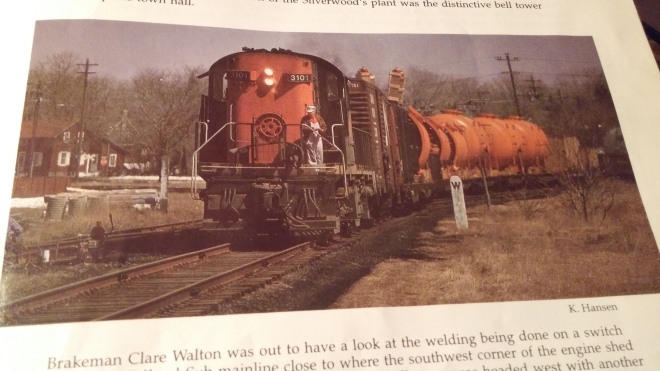
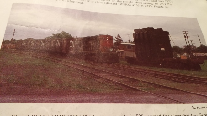
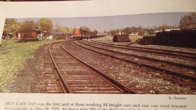
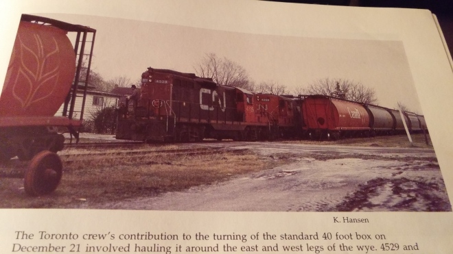
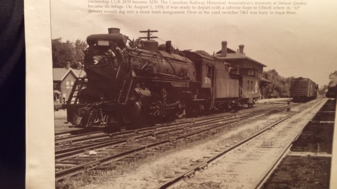
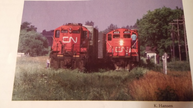
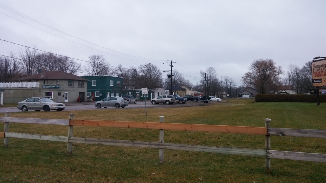
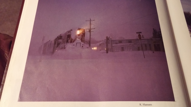
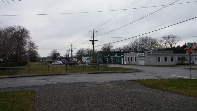
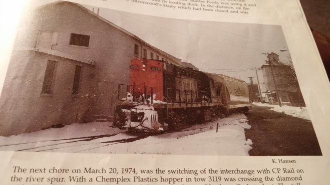
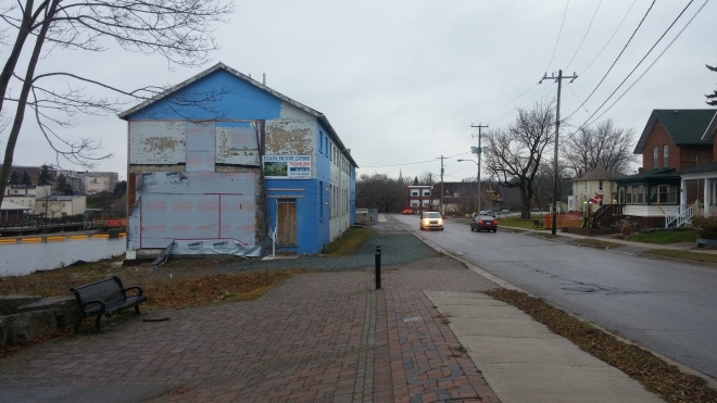
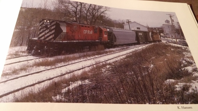
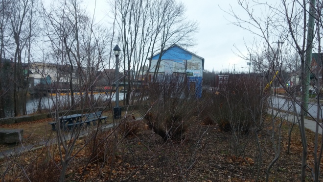
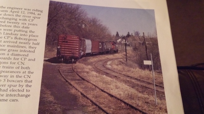
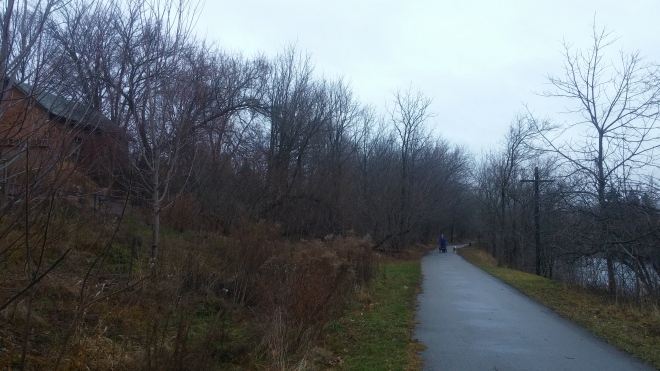
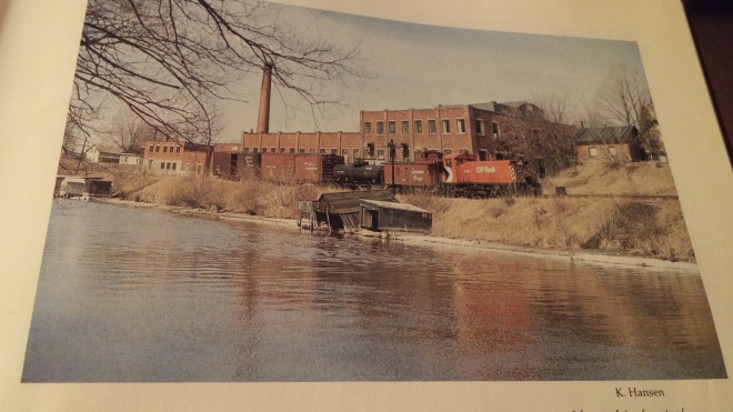
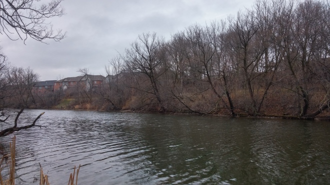
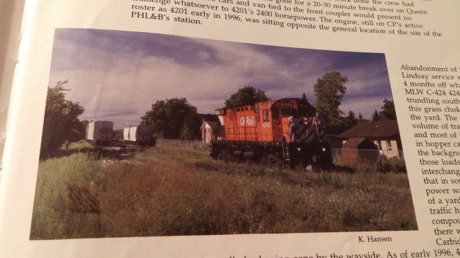
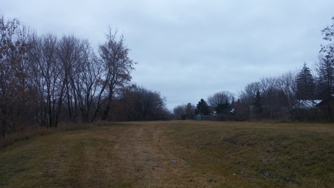
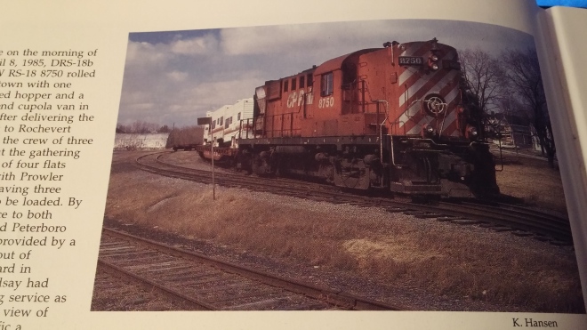
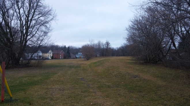
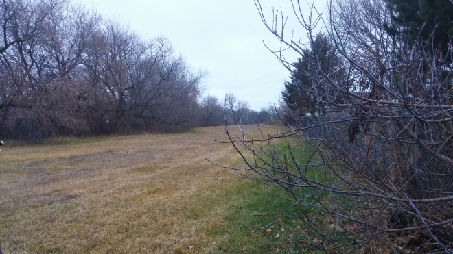
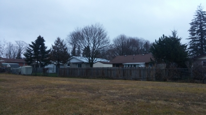
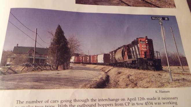
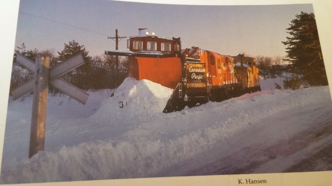
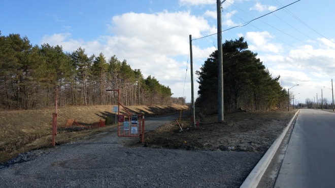
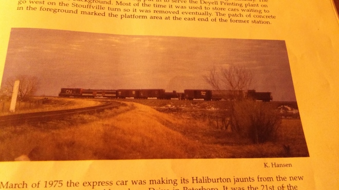
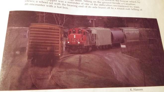
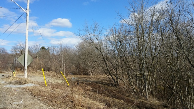
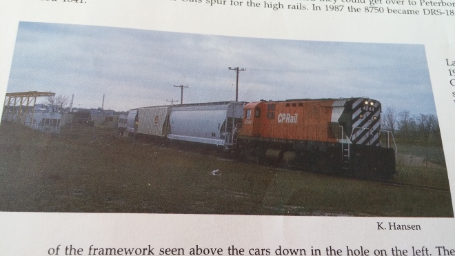
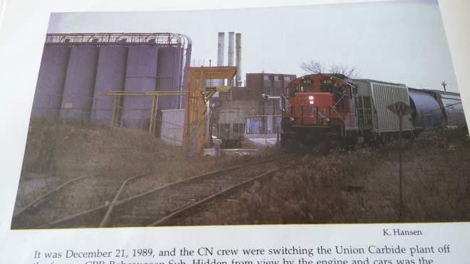
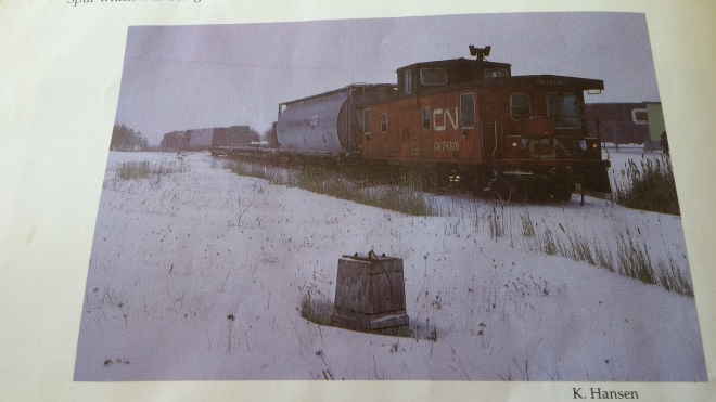
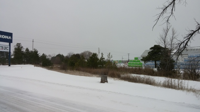
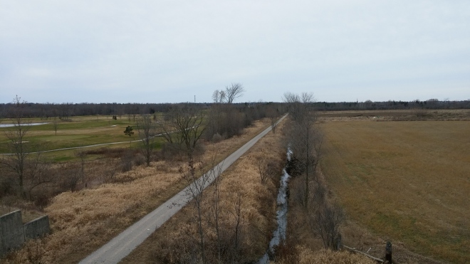
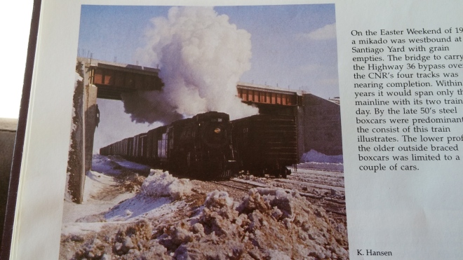
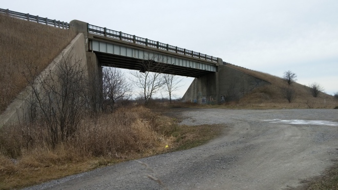
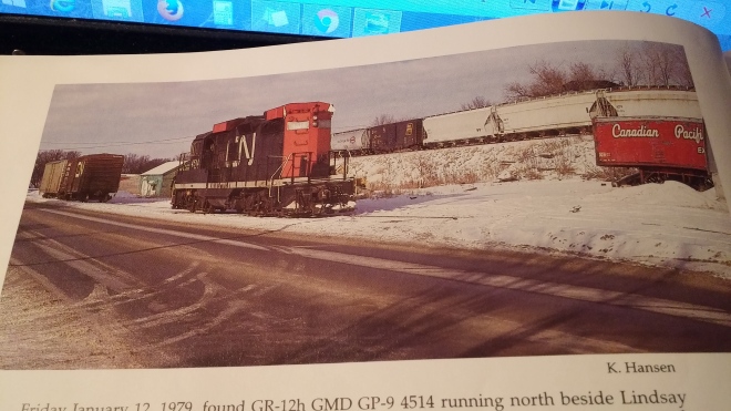
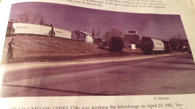
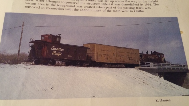
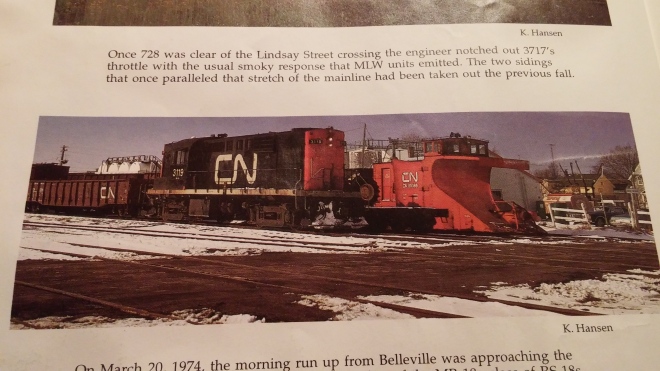
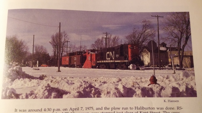
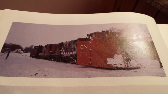
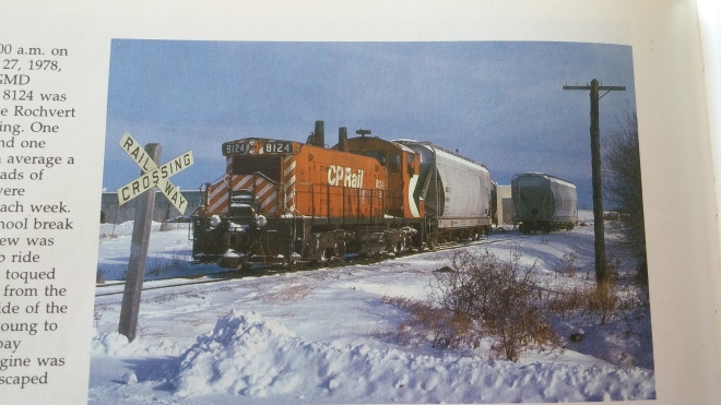
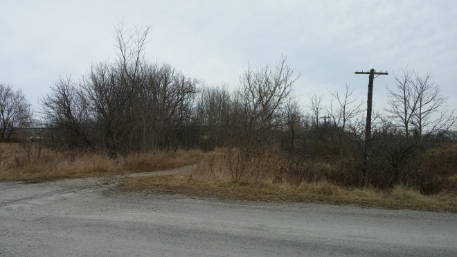
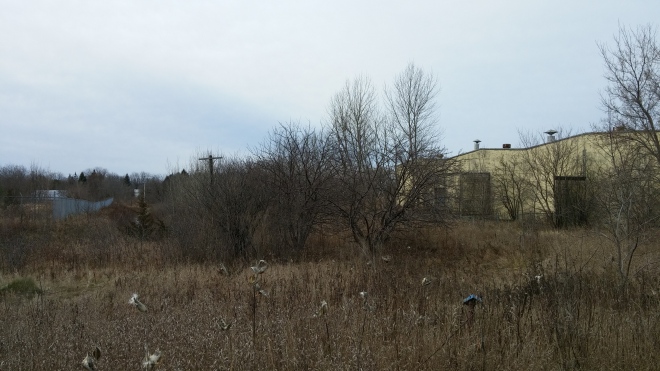
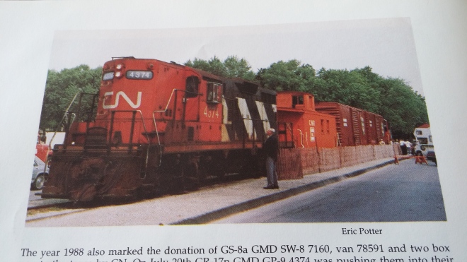
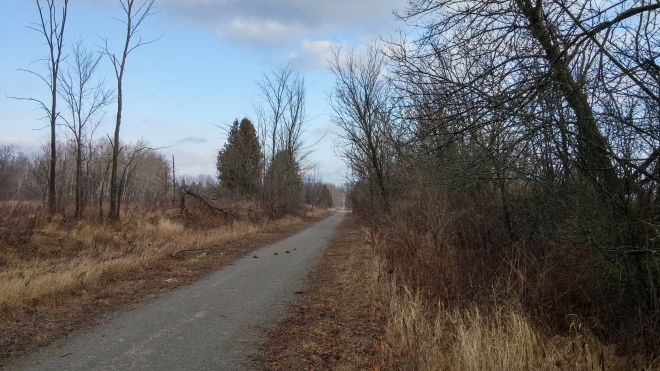
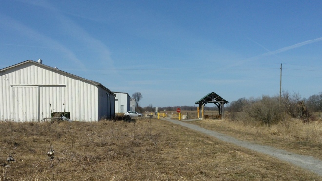
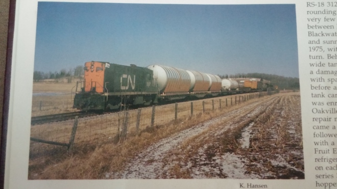
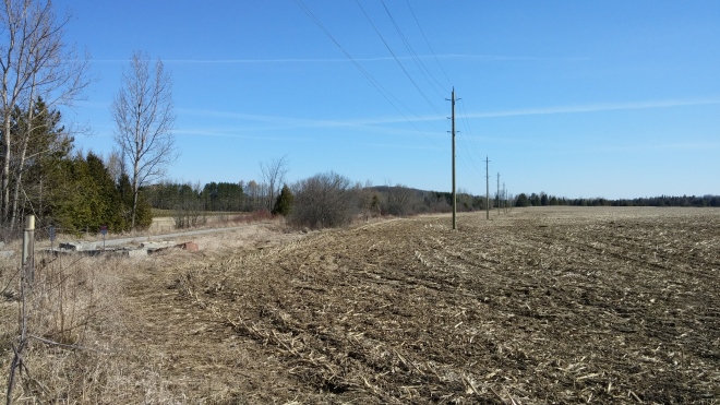
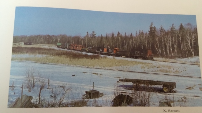
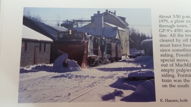
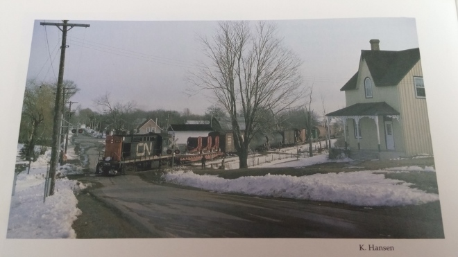
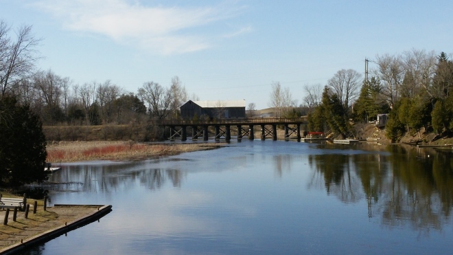
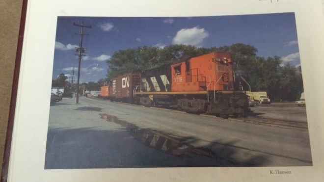
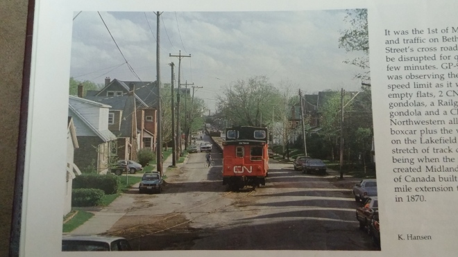
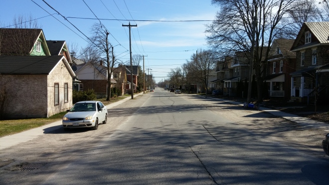
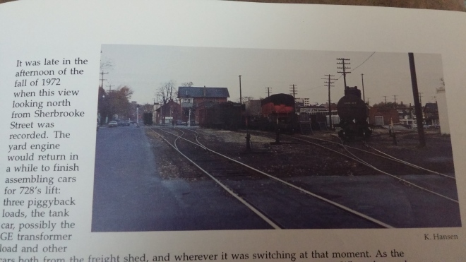
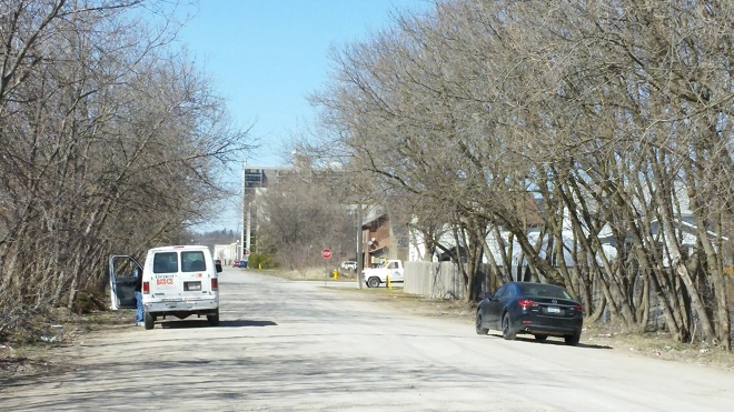
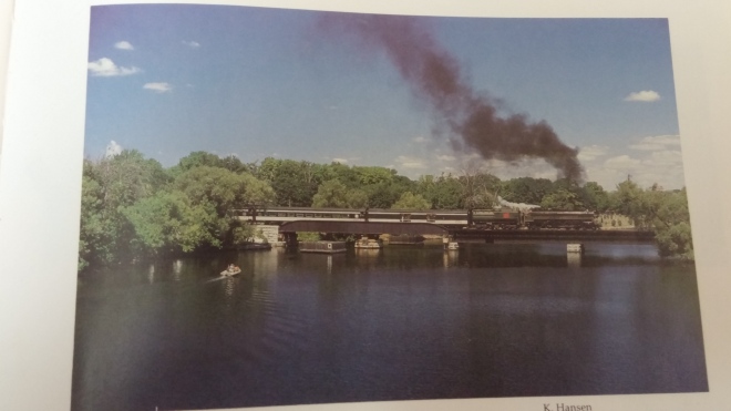
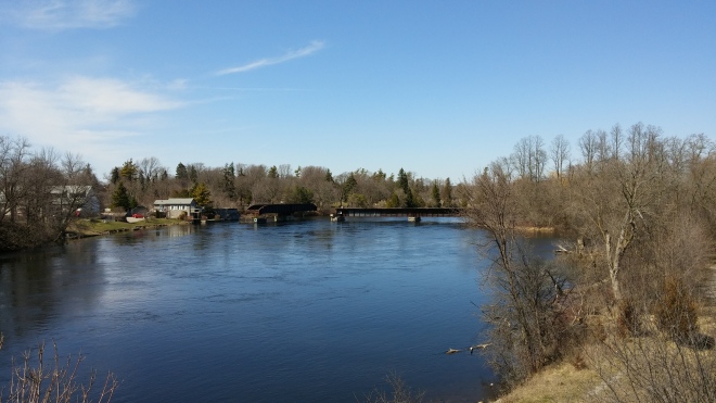
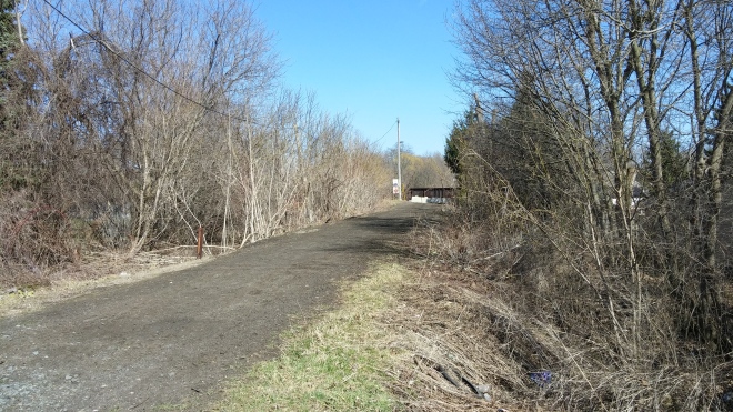
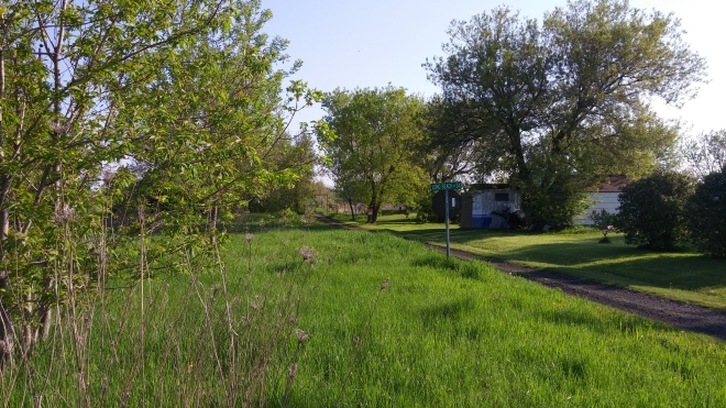
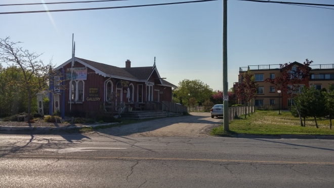
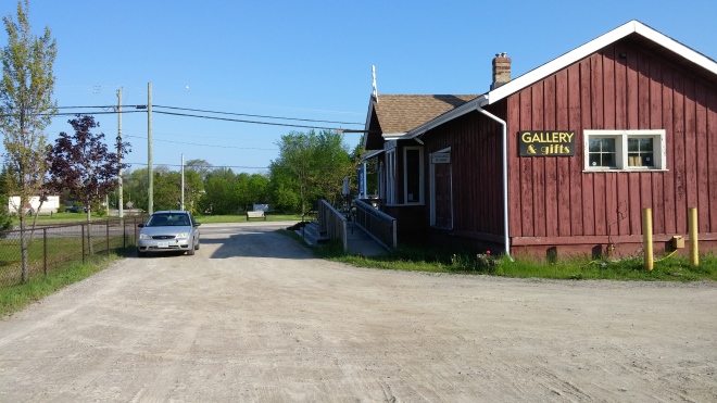
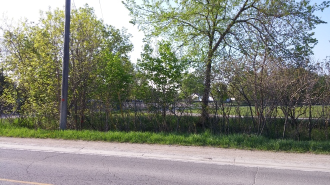
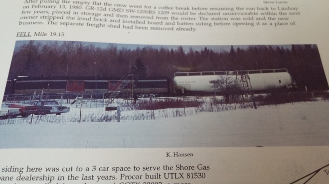
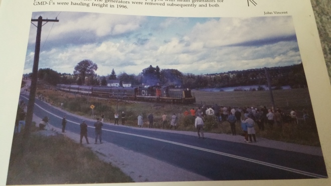
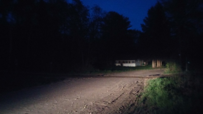
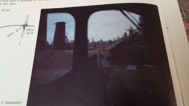
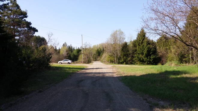
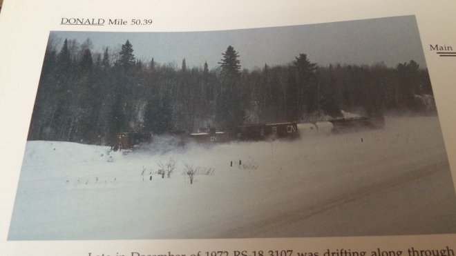
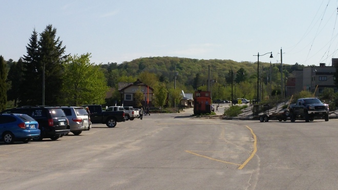
NOW: You would never know in 2015 that the land along Durham Street was once the primary railway lands of Lindsay. While it was the most well known/documented section of track in town, it is also the section that has been developed on the most. Today, an entire housing subdivision sits on the former yard. It’s likely the residents have no idea that a train would be sitting in their backyards less then thirty years ago. Photo taken in December 2015.NOW: A pedestrian trail now follows the perimeter of what was Durham Street yard. The trail connects Trailway Ln and James St to Lindsay St. The houses on the left sit where the station, mainline and passing tracks once existed. Photo taken in December 2015.THEN: Due to train service being cut to once weekly, the Durham Street yard is barely visible through the weeds. These two train sections arrived as one, and split in Lindsay. The section on the left contains the Lindsay cars, and the engine will soon fire up and drop them off at their locations. The section on the right is about to continue to Peterborough to complete work there. Once finished, the two sections will combine again in Lindsay, and will continue west to Toronto. Photo taken by Keith Hansen in July 1987 looking west from Lindsay St (Hansen, p.68).NOW: While the weeds are gone in 2015, they have been replaced by houses and gravel. The creation of a housing subdivision has obliterated the railbed between Lindsay and Hamilton Street. The former railbed is now sandwiched by a Tim Hortons to the left, and a gas bar to the right. Photo taken in December 2015.THEN: A westbound Canadian National train, lead by an RS-3, crosses Lindsay Street. Trailing behind is the midway, which will be part of the upcoming Lindsay Central Exhibition. Photo taken by Keith Hansen. While no date or year is given, the caption mentions it was taken shortly after the closing of the Lindsay “express freight shed office” in June 1964. That and the arrival of materials for the fall exhibition would place this photo as being in August/September 1964 (Hansen, p.39).NOW: Photo taken at the same location in December 2015. The trains have been replaced by cars in a fenced in lot. While previously accessible as a bike trail, the lot is now private property. The Lindsay Exhibition is still going strong, however the fairgrounds are at a new location.THEN: An eastbound Canadian National train battles a snowstorm as it crosses Duke St while enroute to Belleville. This location is at the east end of the Durham St yard, and used to have two tracks paralleling the main line. While snow covers all signs of the tracks, only the main line was left at this time. Photo taken by Keith Hansen in April 1975 (Hansen, p.52).NOW: Recent housing development has obliterated all traces of the railbed between this location and Nayoro Park. Car garage on the corner is still present, and now serves as “Doc’s Auto”. Photo taken in December 2015.THEN: With so many railway lines extending out of Lindsay (5-8 depending on the decade), some were bound to cross over each other at some point. This photo displays a Canadian National train crossing over a “diamond” crossover point, where the Canadian National River Spur and Canadian Pacific Bobcaygeon Subdivisions met each other. The building to the left of the engine is the former Lindsay pajama factory. An old grain elevator is also present in the background. Photo taken by Keith Hansen in 1974 (Hansen, p.45).NOW: While the diamond is gone, the pajama factory remains, despite being partially gutted by a recent fire. The old grain elevator also fell victim to fire, and has been replaced by Tastee Shack. Only traces of the Canadian National railbed remain behind me. The Canadian Pacific tracks have since been repaved into a walking trail, extending 1.5 km to Logie street, where it continues as a dirt trail. Photo taken in December 2015.THEN: Keith Hansen also caught Canadian Pacific action at the King Street diamond. Here a southbound train, headed by C-424 4201, pauses on the diamond before departing for Peterborough. The train is stopped beside the location of Lindsay’s first train station, which served the Port Hope, Lindsay & Beaverton Railway. Photo taken by Keith Hansen in winter 1985 (Hansen, p.455).NOW: This photo taken in December 2015 demonstrates the work done by the Rotary club to develop both the trail, and the area of Lindsay’s first train station. Bushes made it tricky to stand in the proper position.THEN: A Canadian National GP-9 coasts down the River Spur with a cut of cars for the interchange yard. This image demonstrates how the Canadian National and Canadian Pacific tracks (on the right) passed in close proximity for an approximately one kilometer stretch. The River Spur was the remains of the first mainline to pass through Lindsay, built by the Port Hope, Lindsay & Beaverton railway. Cumbersome grades in each direction and a tricky crossing of the Scugog River made the line a burden, and resulted in a new mainline being constructed to the south, and the removal of most of the original mainline. The short spur remaining between the interchange yard and the new mainline remained in use as the River Spur. Interestingly, the River Spur was also one of the final sets of tracks to remain in Lindsay, and was removed when the last of the tracks were pulled. Photo taken by Keith Hansen in April 1984 (Hansen, p.63).NOW: Lots of vegetation and brush have grown up over the right of way. While all tracks and signage in this area have been removed, a telegraph pole remains standing at the right of the path. The overgrowth made finding the exact location of the above photo difficult. The curvature of the river and the houses on the hill at this location lead me to believe that this location is about where the previous photo was taken. While the CP railbed has been preserved by way of the paved Rotary Trail, the River spur has been reduced to a dirt trail through the brush on the left. Photo taken in December 2015.THEN: A southbound Canadian Pacific train departs Lindsay following alongside the Scugog River. The former Allan and Hansbury building sits in the background between the tracks and King Street. The train will head to Peterborough, where it will join with Peterborough traffic, and head west to Toronto. Photo taken by Keith Hansen in March 1975 (Hansen, p.451).NOW: Much has changed in 2015, however the railway embankment remains intact. The Allan and Hansbury plant has been replaced by new houses, and the boat houses have been replaced by trees. Photo taken from Kent St East across the river.THEN: A CP C-424 switches cars in what remains of the CP yard. The once modest sized yard has now been reduced to a single through track with two sidings, and both have become overgrown. Photo taken by Keith Hansen in 1987 (Hansen, p.455).NOW: No tracks, siding, or structures are present in 2015. The CP/CN yard & interchange lands have remained surprisingly undeveloped, especially when compared to the CN station grounds and Durham Street yard. The town of Lindsay did consider purchasing a set of passenger cars from Orillia, and placing them at this spot as part of a railway display. The plan was scrapped however, and the land remains undeveloped to this day. Photo taken in December 2015.THEN: A Canadian Pacific RS-18 does switching in the yard. The car behind is loaded with trailers from Fleetwood. Canadian National had a small yard of their own to the left of the photo, and the track in the foreground served as an interchange between the two railways. Photo taken by Keith Hansen in April 1985 looking north from Queen St. Caroline St is visible at the right of the picture (Hansen, p.454).NOW: While no tracks remain in the present, the former railyards remain surprisingly untouched. The Canadian Pacific tracks followed the raised ground, while the interchange tracks went downhill towards the houses. Photo taken in December 2015.THEN: A Canadian Pacific steam engine and caboose pause at the Canadian Pacific Station. Once work was finished in Lindsay, this small train would soon depart south to the Canadian Pacific mainline at Dranoel. While the station is a popular place in this photo, it would be gone within the next decade. Photo taken by R.J Sandusky in November 1958 (Hansen, p.448).NOW: Photo taken in 2015 standing at the approximate location of the Canadian Pacific station. The station has been gone for a long time, and no evidence of it remains. It was vacated in 1961, and demolished in 1964.THEN: This photo also captures a Canadian Pacific steam locomotive stopped with a train out front of the Canadian Pacific Lindsay station. This photo displays the famed”witch’s hat” structure of the station. The Bobcaygeon Subdivison branched north from the CP mainline at Dranoel. It snaked through Lindsay before headed northeast to Bobcaygeon. The engine is facing south, which indicates it likely ran to Bobcaygeon that day and turned around on the turntable there. Despite this indication, service to Bobcaygeon would be discontinued within the next three years, making Lindsay the new end of the line. This photo is from the Paterson George Collection, and was taken in August 1958 (Hansen, p.447).NOW: Not even the foundation remains in 2015. Only grass remains. Houses have been built up around the station access point, leaving no indication of what was in the past. While Lindsay’s “witch hat” station is gone, a similar type station can be found southwest of Lindsay still preserved in the town of Uxbridge. Photo taken in December 2015.THEN: A Canadian National train pulls a string of cars uphill along the River Spur at the intersection of Logie Street and Riverside Drive. This location was formerly the edge of town, and as such, Logie Street was a gravel road. This train will continue up the hill to the mainline, and then reverse westbound to the Durham Street yard. Photo was taken by Keith Hansen in April 1984 (Hansen, p.63).NOW: As Lindsay expands outwards, improvements have been made to the roads and subdivisions. Where the tracks crossed Hillside Drive is now a bus stop. You can follow the railbed of the River Spur west from where it crosses Logie St, however there is no longer any trace of it between there and the former mainline. Photo taken in April 2015.THEN: A Canadian Pacific plow train, powered by an RS-18, pauses at the Logie Street crossing. The caption states the train was stopped while workers cleared the switches in town. Once that work is completed, the train will continue into town and clear the trackage there. Photo taken by Keith Hansen. No date given (Hansen, p.443).NOW: This location today is now accessible as a biking trail in the summer, and a snowmobiling trail in the winter. The paved Rotary trail portion of the line ends behind me. Despite the addition of a new subdivision to the left of the photo, and a realignment of Logie street to the right of the photo, the railbed still remains. The portion of the Bobcaygeon subdivision through Lindsay was actually shared by two railways initially. The Georgian Bay and Seaboard railway ran between Port McNicoll and Dranoel, and the Lindsay, Bobcaygeon and Pontypool railway ran between Bobcaygeon and Burketon. The two railways met just north of the CP Lindsay yard, and ran on shared tracks to a point just south of this photo. Here the tracks branched apart at what was called “Lindsay Junction”, which contained a small station. Both tracks were eventually leased by Canadian Pacific, giving them two access points to their mainline through Central Ontario. When both lines fell on hard times, CP abandoned the southern portion of the LB&P and the northern portion of the GB&S, and made one line based on the remaining sections. The combination of these sections became what was known as the Bobcaygeon subdivision. Photo taken in April 2015.THEN: An eastbound Canadian National train departs Lindsay for Belleville on the Campbellford Subdivision. The River Spur curves up along the left of this picture. This marks the point where the new mainline through town branched away from the old mainline. The train has just crossed over the high bridge over the Scugog river. Photo taken by Keith Hansen in March 1975 (Hansen, p.49).NOW: It’s hard to believe this image in the same place. A new subdivision has been built over the area, and both the old and new right of ways are obliterated. The two tracks were built on a steep embankment, which made it an excellent sledding and biking location in my childhood days. There was also a small bridge over Logie Street which while being present at the time of the previous photo, has since been removed. Photo taken in April 2015.THEN: The River Spur saw the last traffic that rolled in and out of Lindsay. A Canadian National GP-9u pulls a string of cars down the River spur enroute to what remains of the CN/CP interchange, and will likely shove the car in front of it to its destination. Photo taken by Keith Hansen in December 1988 (Hansen, p.73).NOW: This location was one of the toughest to locate. This photo, taken in April 2015, is in the approximate location of the previous photo. The River Spur curved through the level area in the foreground. Riverview Drive ends to the left of the photo, with a dirt path connecting the road to the trails below. Through the trees is the “Rainbow Bridge”, which provides pedestrian access across the Scugog RiverTHEN: A Canadian Pacific train switches cars at Union Carbide. Union Carbide was one of Lindsay’s main rail customers towards the end of service, and helped to keep trains arriving to Lindsay well into the eighties. The train is sitting on the tail end of the Bobcaygeon Subdivision, with the end of track being to the right of the photo. This had been the case since 1962, when the tracks between Lindsay and Bobcaygeon were removed. Photo taken by Keith Hansen in fall 1985 (Hansen, p.454).NOW: Union Carbide no longer remains in December 2015, and the tracks are also gone. The route of the mainline is still clearly visible curving across the photo, and it is currently used as an informal hiking/biking trail, The route of the mainline continues across Highway 36, which is located behind me, to the next concession road east. While it can be accessed and explored, it is very overgrown.THEN: Once Canadian Pacific ceased operations in Lindsay in 1987, Canadian National took over servicing the industries along what remained of the Bobcaygeon Subdivision. In this photo, a CN train is about to switch cars at Union Carbide. Rail services was dwindling at this time, and plans were already being put in motion to abandon all tracks Photo taken by Keith Hansen in December 1988. (Date on photo caption is listed as 1989, however other photos of CN #4111 and this train in this book list date as 1988) (Hansen, p.74).NOW: The access siding to Union Carbide slopes straight ahead, while the path of the main line curves to the right. Photo taken in December 2015. Since this area was one of the last to have its tracks removed, much evidence of their presence remains. Rail spikes and fishplates can be found on the ground along the path.THEN: While previously serving as the main western artery out of Lindsay, the Midland Subdivision was reduced to a short industrial spur in the sixties. A Canadian Nation train services the United Co-op. The Co-op and Uniroyal were the two customers on this short stub of track. The foundation in the foreground is the remains of crossing protection for the Highway 7B access road into Lindsay. Photo taken by Keith Hansen in March of 1986 (Hansen, p.64).NOW: An overnight snow/ice storm has given this area in 2015 the same snow covered appearance as it had in 1986. Harvest Road passes in the foreground, providing access to Kawartha Lakes Honda, and Polito Ford & Lincoln. While the railbed remains visible, it is quite overgrown both in front and behind this location. The co-op has now become a Rona. The concrete foundation from 1986 has surprisingly survived into 2015. Highway 7B passes behind my location by way of a large concrete overpass. The railbed extends about 400 meters past the overpass, where washouts and land development have made it inaccessible.THEN: A very short Canadian Pacific train heads south across the Lindsay town line towards Peterborough via Dranoel. The unit on the head end is an RS-23, an engine model which is no longer used by Canadian Pacific. RS-23’s can be found on short line railways, including the Ontario Southland Railway. The train is about to pass under the Highway 7 bypass around Lindsay, and is just west of the junction between Highways 7 & 36. Photo taken by Keith Hansen in fall of 1975 (Hansen, p.442).NOW: The railbed still remains in 2015, however the tracks have all been removed. The railbed is now used as the southern leg of the Victoria Rail Trail. The farmers field in the previous photo is now home to the Lindsay Golf and Country Club. While the western water tower was visible in the previous photo, it is not visible in 2015, as it was torn down in 2007. Photo taken in December 2015.THEN: A westbound Canadian National empty grain train passes under the soon to be completed Highway 36 overpass. The box cars to the left of the train are on one of the Santiago yard tracks. Initially built to deter the Lindsay Bobcaygeon & Pontypool Railway from entering Lindsay, it was now becoming redundant, and would be removed in a few years. Photo taken by Keith Hansen in winter/spring 1959 (Hansen, p.30).NOW: The overpass remains today carrying Highway 36 over the former location of Santiago yard. This location now serves as an access point to the Trans Canada Trail, which follows the tracks east under the bridge towards Peterborough. The trail also extends west of this location, snakes through Lindsay, and then continues west to Uxbridge. Photo taken in December 2015.THEN: A Canadian National GP-9 sits on the tail track of the CN portion of the interchange yard. The cars above the engine are on Canadian Pacific tracks. The yards for each railway at this location consisted of only a few sidings, and were connected by a team track in the middle. This interchange allowed Canadian National to access freight traffic from the industries along the end of Canadian Pacific’s Bobcaygeon Subdivision. CP would drop cars into the CN yard by way of the team track, and CN would pick them up and move them to their larger yards downtown, after spotting their own cars for CP to deliver to their businesses. Photo taken by Keith Hansen in January 1979 (Hansen, p.60).NOW: The tracks are all gone in today, and only trees remain. Lindsay and Colborne Streets have been realigned since 1979. Lindsay street previously curved around the end of the yard and became Colborne Street East. The road now curves and rises into the former yard on an S curve, and rejoins Colborne Street as a point just east of the tracks. The CP tracks crossed Colborne Street by way of a small overpass, which was removed in the late nineties. Photo taken in December 2015.THEN: A Canadian National SW-1200RS works the CN portion of the interchange yard. The box cars in the centre of the picture are on the interchange track between the two yard sections. The Lindsay grain elevator visible in a previous photo, is also visible between the engine and the boxcar. Photo taken by Keith Hansen in April 1982 (Hansen, p.61).NOW: The tracks, trackside structure, and grain elevator are all gone. The white residence visible between the engine and boxcar in the previous photo remains in the present. Photo taken in December 2015.THEN: A Canadian Pacific locomotive crosses the Colborne Street East overpass as it runs around its train. At this time the overpass carried two tracks, and it was converted into a single track bridge some time after this photo was taken. The reason for its original alignment was likely due to this location being the northern junction point between the Lindsay Bobcaygeon & Pontypool, and the Georgian Bay & Seaboard Railways. These two lines branched away from each other just behind the photographers location. Photograph part of the Patterson George Collection, and was taken in July 1958 (Hansen, p.446).NOW: Evidence of the new road alignment and the removal of the overpass is present in this photo taken in December 2015. The railbed is present to the left of my location, and continues up until the former end of track at Highway 36. Very little remains of the Georgian Bay & Seaboard railbed, as it has fallen victim to development and overgrowing plant life. Part of the embankment can be traced through the northern end of Rivera Park, where it is now used as a tobogganing hill.THEN: A Canadian Pacific SW-1200RS heads northbound across the Colborne Street East overpass. A boxcar and caboose trail behind. At this point in time, the bridge only carried one track over the street. Photo taken by Keith Hansen in March 1974 (Hansen, p.449).NOW: So much has changed in December 2015 that this picture seems out of place. All traces of the bridge have been removed, as has a large portion of the rail embankment. The lack of remaining infrastructure made finding the exact location tricky.THEN: A Canadian National SW-1200RS heads north along Victoria Avenue, and is about to cross Bond Street. As a result of acquiring the Victoria Railway, the Midland Railway had an abundance of lines in and out of Lindsay. They chose to use the Victoria Railway route north out of Lindsay for the route of their new Midland/Belleville mainline, which helped to avoid the cumbersome grades along the former mainline. This route met the old mainline at Victoria Junction, and continued west to Midland. Numerous level crossings and a steep grade out of Victoria yard brought along similar issues with the new route as traffic increased. The third and final route alignment was built heading northwest from the Lindsay wye in 1907, meeting the original mainline at Thunder Bridge. Photo taken by R.J Sandusky in November 1958 (Hansen, p.29).NOW: The tracks no longer remain, having been removed in 1983. The tracks have been replaced by curbed medians, which extend north along Victoria Avenue to Orchard Park Road. The house and trees on the right edge of the previous photo in 1958 are still present in this December 2015 photo.THEN: A Canadian National RS-18 leads the Haliburton wayfreight north across Bond Street. The train is running north along Victoria Avenue slightly further north from the 1958 photo. The Haliburton Subdivision ran north from Lindsay Junction to Haliburton, and extended south down Victoria Avenue to access the yards in downtown Lindsay. The line was originally constructed by the Victoria Railway, and was later operated by the Midland, and Grand Trunk Railways. Canadian National became the line’s final operator up until its abandonment. Photo taken by Keith Hansen in March 1974 (Hansen, p.46).NOW: This second December 2015 photo captures the route of the Victoria Avenue trackage from the other side of the street. The tall house on the corner was also present in the previous photo. The steep grade northbound trains had to contend with is visible in this photo. This grade extended from Peel Street to Regent Street. This grade was part of the reason Midland Railway stopped sharing these tracks, and built their own cutoff further south.THEN: A Canadian National RS-18 and GP-9 haul freight cars east over the high level Scugog River bridge. The caption states the train is destined for the interchange yard and River Spur. Once the train has crossed this bridge and the adjoining Logie Street overpass, it will reverse down the River Spur to the yard. The Canadian Pacific Bobcaygeon Subdivision can be seen ducking under the eastern span of the bridge. Photo taken by Keith Hansen in April 1984 (Hansen, p.64).NOW: The bridge still stands tall over the Scugog River. Photo taken in April 2015. Wooden frames are now installed to deter people from climbing along the outside of the structure. Both the CN and CP tracks are gone, as is the Logie Street overpass, which was dismantled in 2009. It would have formerly been visible at the right edge of the photo where the trees are. The pathway over the bridge slopes down to street level at Logie Street, and the alignment can be partially made out just to the right of the bridge. While formerly serving trains, this bridge serves as an important link for pedestrians and cyclists passing east-west through Lindsay. Prior to the dismantling of the Logie Street bridge, the route also allowed snowmobilers to access the trails east of Lindsay. The railbed east of the River Spur connection is now part of the Trans-Canada Trail. Despite this, development to the east has rendered the bridge obsolete. At the time of this writing, its future remains uncertain.THEN: Numerous freight cars and a pair of SW-1200RS units are idling in the Victoria yard. Photo is taken looking north from Durham Street. The tracks in the foreground form the western leg of the Lindsay wye. Photo taken by Keith Hansen in the summer of 1970 (Hansen, p.42).NOW: A Community Care housing village now sits in this location. Photo taken in December 2015. The red brick house beside the Community Care building is also present in the previous photo. A station and freight shed was formerly present in the Victoria yardlands. The latter remained present into the nineties, and was torn down for development in 2006.THEN: Canadian National RS-18 3119 creeps up to the Glenelg Street crossing in the Victoria Avenue yard. The Victoria Avenue yard was one of two CN yards present within downtown Lindsay, with the second being the Durham Street yard. The yard was located to the north of the Lindsay wye. The mainline that passed through the yard was initially formed by the connecting of the Whitby, Port Perry & Lindsay railway, and the Victoria Railway. In later times, it was the connection between the CN Uxbridge and Haliburton subdivisions. A union station was located at this junction up until 1890. A CN snow plow can be seen beside 3119. Photo taken by Keith Hansen in March 1974 (Hansen, p.44).NOW: Development has eliminated most traces of the yard. Photo taken in December 2015. The freight shed would have been visible at the left of the photo prior to 2006. Condominiums will be going up in the location where tracks and trains passed previously. Glenelg Street has also evolved into a more modern road.THEN: A Canadian National plow train pauses on the Haliburton Subdivision after clearing the line up to Haliburton. The train is lead by RS-18 3114. The train is just past the northern limits of the Victoria yard. The location is also where street running began along Victoria Avenue. Photo taken looking north from Russell Street. Lindsay’s town hall can be visible beside the RS-18, between the engine and the stop sign. Photo taken by Keith Hansen in April 1975 (Hansen, p.53).NOW: Much has changed between 1974 and 2015. While town hall is still standing, it is barely visible from this location. Kent Place Mall now dominates the area beside Victoria Avenue. The vacant land in the previous photo is now a parking lot, serving a strip mall, Home Hardware, and Tim Hortons. Even the stop sign in the previous photo has been replaced by traffic lights. Photo taken in December 2015.THEN: A Canadian National plow train sits at the northern end of the Victoria Avenue yard. Unlike in the previous photos, the train had not gone to and from Haliburton, as the tracks had been removed up until a point just behind the train. The train is sitting beside the Lindsay freight shed. Photo taken by Keith Hansen in March 1984. (Hansen, p.62).NOW: Condominium development has also eliminated the northern portion of the Victoria Avenue yard. Photo taken in December 2015. The tracks of the yard and mainline curved towards Victoria Street at this location, meeting the road where it intersected with Russell Street. Once there, the tracks ran up the middle of Victoria Avenue.THEN: A Canadian Pacific SW-1200RS switches cars at Rochvert Plastics. While Lindsay had lost its terminal status in April of this year, the changes primarily affected Canadian National traffic, since Canadian Pacific trains were based out of Toronto. The decline of CP service had begun decades earlier, when the opening of the current Welland Canal made moving trains of grain through Central Ontario redundant. This was further amplified by The Great Depression of the 1930s, and the loss of passenger train service in the fifties. This lead to freight services being provided as it was needed in the final thirty years of CP service in Lindsay. Photo taken by Keith Hansen in December 1978 (Hansen, p.452).NOW: Photo taken looking east from St Peter Street in December 2015. The area has become overgrown, but the railbed is accessible between here and Highway 36. Mound of gravel make for tricky walking in the stretch behind me. The telegraph pole remains from the previous photo. This location also contains two small segments of rail that have not been removed. The first can be found in the asphalt to the left of this photo. There is also a small stub of track that crosses the road behind my location, and extends for a few meters into the field at the right of the photograph. The longer track stub is the remains of a siding that ran into Abex Industries, which manufactured auto parts. The factory has since been demolished.THEN: A Canadian Pacific SW-1200RS switches cars west of St David St. The train will pick up the boxcar beside it, and add it to its train for the run out of Lindsay. This train was seen passing the Allan & Hansbury building in a previous photo. The building beside the train was formerly Schultz Diecasting, and later became Rochevert Plastics. Photo taken by Keith Hansen in March 1975 (Hansen, p.450).NOW: The tracks and siding have been removed, however the loading ramp area remains visible. The building still stands, and now operates as Canopy Plastics. The creek and telegraph pole from the previous photo is also present in this photo taken in December 2015..THEN: A Canadian National GP-9 eases a display train onto the stub of the former Haliburton Subdivision. The display train consists of CN SW-8 7160, two CN boxcars, and CNR caboose 78591. The engine and cars were donated to commemorate Lindsay’s history as a railway terminal. Within the next three years, all tracks within the Town of Lindsay would be removed, and the display train would be landlocked in the middle of Victoria Avenue. Photo taken by Eric Potter in July 1988 (Hansen, p.72).NOW: Only the median remains in this photo taken in December 2015. The display train sat at this location for ten years between 1988 and 1998. It was then moved to Memorial Park, and it remains at this location today. The display train has gone through numerous cosmetic changes since being moved to its current location. The SW-8 has been restored and repainted twice, and is now black. The original van fell victim to arson, and has been replaced by a steel van from a private donor. The display train is partnered with a second train, consisting of TH&B 0-6-0 42 and a wooden CNR caboose. More information on the display can be found online, on Panoramio, or by visiting it yourself. Display is located on Lindsay Street south of Mary Street.THEN: A Canadian National freight, lead by RS-18 3121, crests the hill at the former Manilla Junction near Cresswell. This train is the “Stouffville Turn”, which carried damaged and high/wide loads along the back route between Belleville and Toronto, passing via Lindsay. Manilla is a small village about 20km west of Lindsay on the Trans-Canada Highway. Manilla Junction was an important connection in earlier days. The route of Whitby, Port Perry & Lindsay Railway curved from the right and ran into Lindsay. The tracks 3121 is standing on were a connection between the WPP&L, and the Toronto & Nippising Railway at Blackwater. Over time, the connecting link became the mainline, and the WPP&L line was abandoned. At the time of this photo, the line was operated as the Uxbridge subdivision, carrying trains between Lindsay and Scarborough via Uxbridge. Photo taken by Keith Hansen in March 1975 (Hansen, p.229).NOW: I found the approximate location of the previous photo while returning home for the holidays in December 2015. Photo taken looking east, about 200 meters east of the Station Road crossing near Cresswell. While portions of the WPP&L railbed are visible to the right of this location, the exact junction point can no longer be determined. A turntable was also located at the junction point. The gravel path follows the Uxbridge Subdivision. Only the fence on the left remains from 1975.
Campbellford/Uxbridge Subdividions
Last Trains From Lindsay also contains photographs and information on train operations on the numerous branchlines that entered Lindsay from all directions. I decided to include additional photo comparisons of scenes along the former Uxbridge and Campbellford Subdivisions. These photos were taken in April 2016 while visiting family in Lindsay. Uxbridge Subdivision photos were taken along the line between Goodwood and Lindsay, while Campbellford Subdivision photos were taken within the city of Peterborough, and along the former right of way between Peterborough and Lindsay.
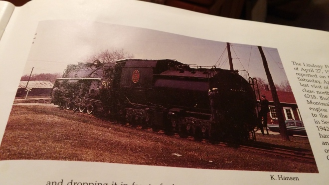
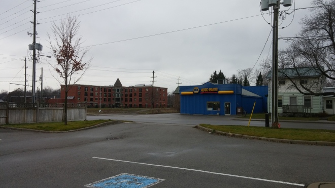
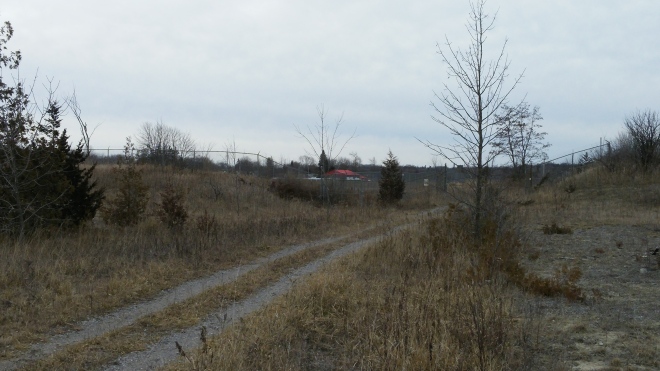
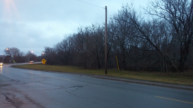
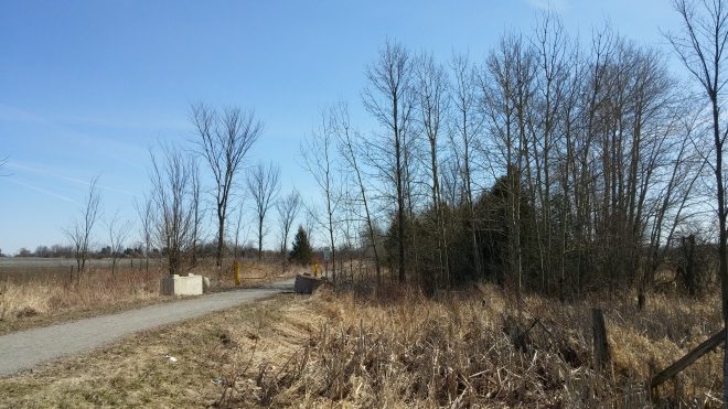
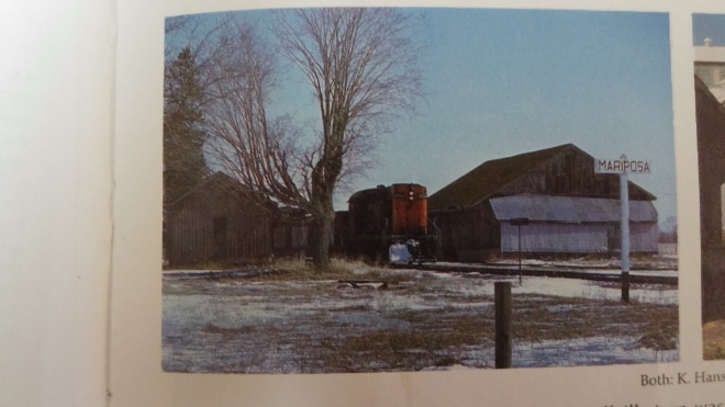
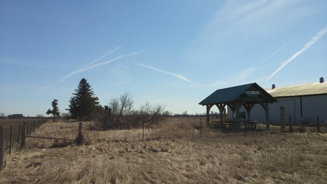
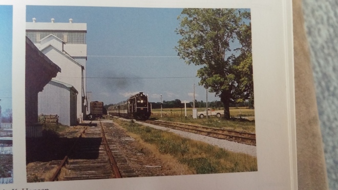
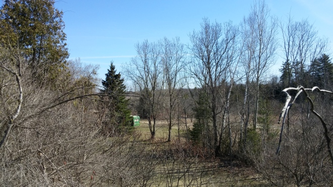
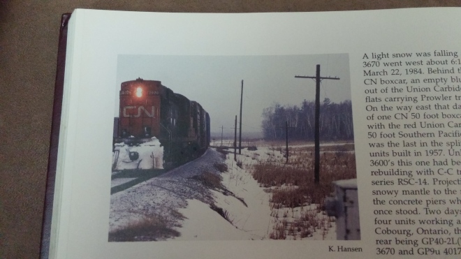
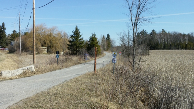
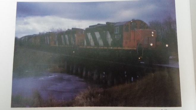
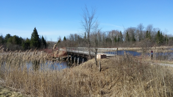
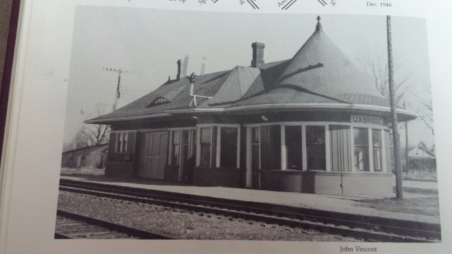
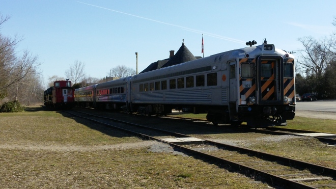
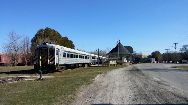
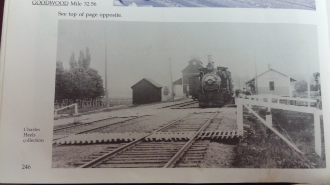
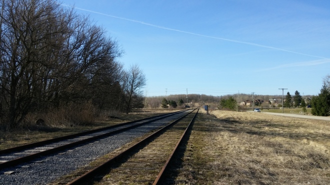
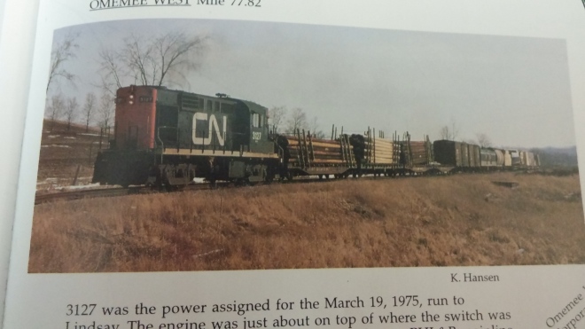
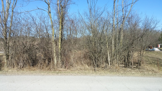
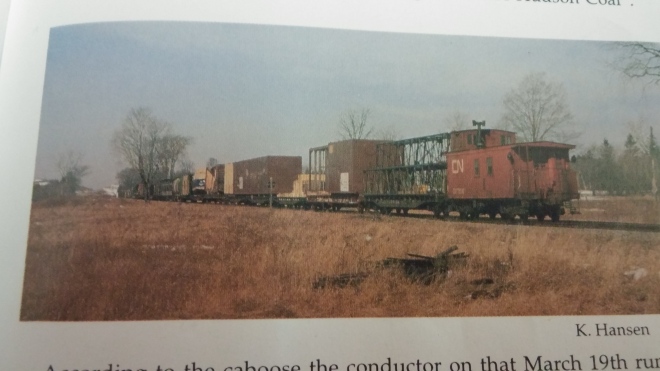
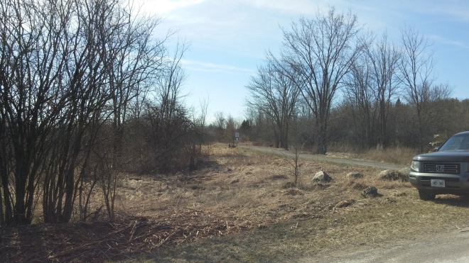
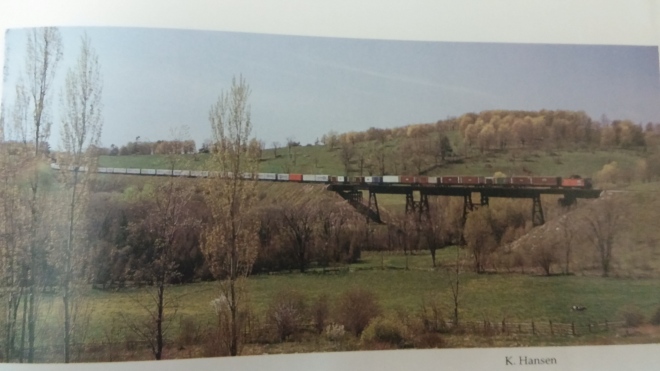
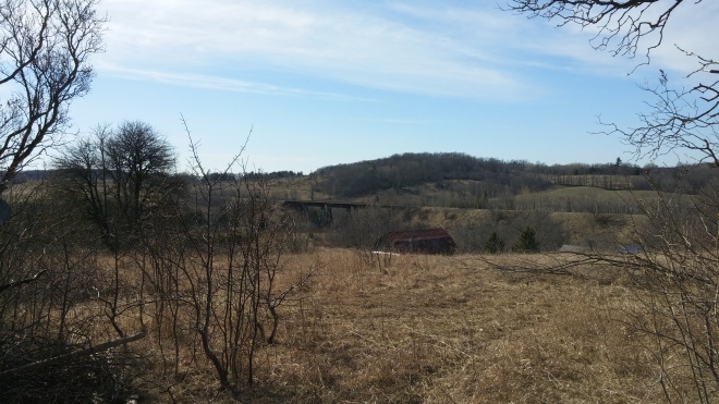
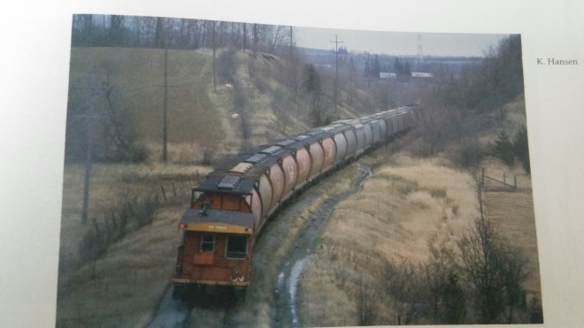
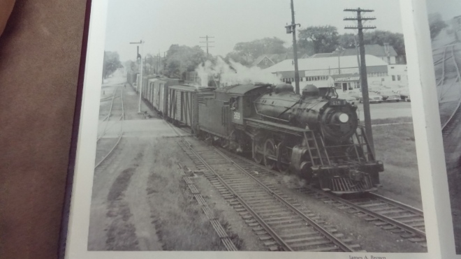
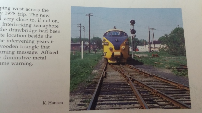
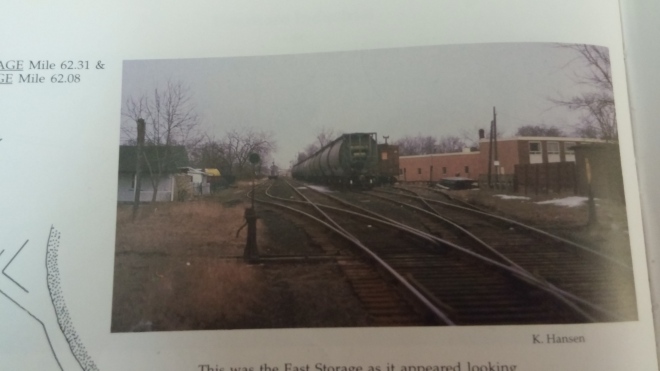
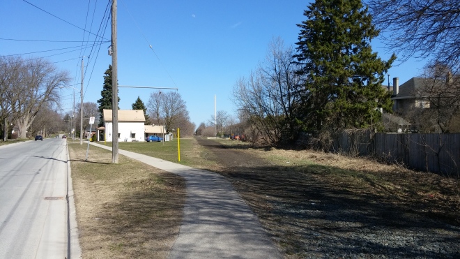
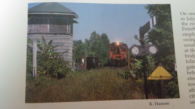
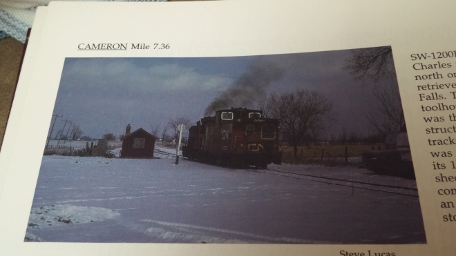
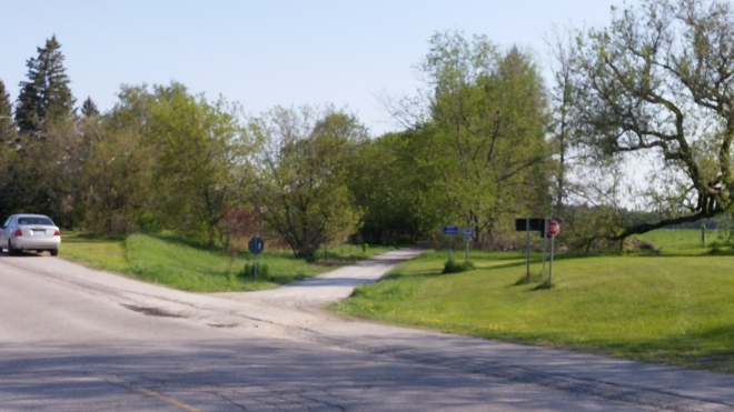
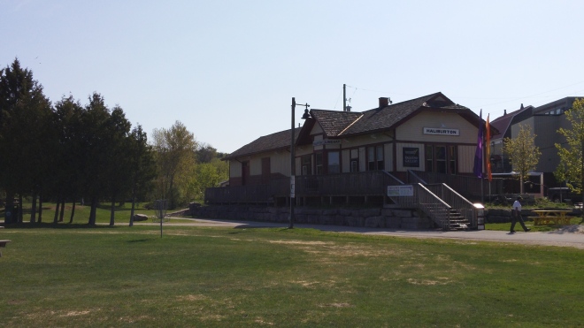
THEN: Canadian National 4-8-4 6218 leads an UCRS excursion train westbound out of Lindsay on the CN Uxbridge Subdivision. The overpass for the Highway 7 bypass is visible on the horizon. The train is about to cross Monarch Road, which is the first level crossing west of Lindsay. Photo taken by Keith Hansen in April 1970 (Hansen, p.227).NOW: The rails at Monarch Road are now gone, with gravel taking their place. The railbed is now part of the Trans Canada Trail. 46 years of tree growth have made the Highway 7 overpass no longer visible from this location, however it remains in use today. Photo taken in April 2016.THEN: The “Stouffville Turn” is westbound out of Lindsay, and is about to pass the Mariposa signboard. Mariposa was a station stop approximately halfway between the communities of Oakwood and Little Britain in the former Mariposa Township. The train is about where the Mariposa station once stood. The former freight shed and other trackside structures are still standing. Photo taken by Keith Hansen in March 1975 (Hansen, p.229).NOW: All the old trackside structures east of Eldon Road have been demolished since the time of the previous photo. A shelter for bikers/hikers now sits beside the railbed, and a storage shed sits across from it. Photo taken in April 2016. The tree in the previous photo stood for years, however succumbed to the elements recently, and is seen cut down in the foreground.THEN: Canadian National 4-8-2 Mountain 6060 rumbles east across Eldon Road as it approaches the site of Mariposa Station. The signboard from earlier is visible beside 6060. The large white trackside structures belonged to Hogg and Lyttle. 6060 lead numerous excursion trains in and around Lindsay in the seventies, and now operates in Alberta on the Alberta Prairie Railway. 6060 was the first of 80 4-8-2 locomotives build for CN, and is one of three who remain as either operational or on display in Canada. An interesting locomotive to see photographed as I have a model of this same locomotive! Mariposa Elementary School is just out of frame to the right of the photo, having opened only three years before this photo was taken. Photo taken by Keith Hansen in July 1975 (Hansen, p.229).NOW: The Trans-Canada Trail marks the location of the mainline, while the path of the siding has been lost to the brush. Interestingly, one of the white trackside structures from the previous photo remains beside the former railbed (as indicated by the roof trim and siding). The large elevators west of Eldon Road have since been removed, and a mixture of new and abandoned buildings remain. Photo taken in April 2016.THEN: Canadian National RS-18 3127 is leading the Stouffvile turn towards Toronto, and is about to cross Side Road 18. The customary high, wide and damaged loads of the turn trail behind. The train is on the link the Midland Railway built to connect the former Whitby, Port Perry & Lindsay, and the Toronto & Nippissing Railways, both of which were acquired by the Midland Railway in 1882. The approximately 6 mile link was built one year later in 1883, and connected Manilla Junction with Blackwater. Photo taken by Keith Hansen in March 1975 (Hansen, p.230).NOW: The plowed field and rising hill in the background confirm this location today. Besides those features and the former railbed, not much remains at this location. The lack of reference points made acquiring this photo a bit tricky. Photo taken in April 2016.THEN: The Stouffville turn prepares to depart Blackwater Junction after spotting two covered hoppers on the east leg of the wye. This junction was a result of the link connecting the Whitby, Port Perry & Lindsay, and Toronto & Nippissing railways. At this time, it served as the junction point between the CN Uxbridge Subdivision and Cannington Spur. While a station and numerous sidings used to be present at this site, only the main line and wye remain. Photo taken by Keith Hansen in March 1975 (Hansen, p.237).NOW: All rails have been removed from Blackwater Junction today. Much of this vantage point has become obstructed by trees since 1975. The path of the west leg of the wye is partially visible through the trees at the right and center of the photograph. Photo taken in April 2016.THEN: Canadian National RS-18 3670 leads a short train through Blackwater, and is about to cross Highway 12. The foundation of the Blackwater Junction water tower is visible beside the train. Photo taken by Keith Hansen in March 1984 (Hansen, p.238).NOW: The railbed is well maintained and in use as a trail. Highway 12 remains, and passes behind my location. Unfortunately, I did not walk the trail to see if the water tower foundation remains. Photo taken in April 2016.THEN: Canadian National GP-9u 4111 and three other units lead a grain train from Toronto to Peterborough. 4111 is square on top on the small trestle over the Beaver River at Blackwater. The train will shortly rumble across Highway 12. Photo taken by Keith Hansen in December 1988 (Hansen, p.238).NOW: The Beaver River trestle still remains, and has been planked over to allow bicycles to cross it. Railings have also been installed to prevent people from driving off the bridge. The trail remains intact all the way to Uxbridge, where rails remain. Photo taken in April 2016.THEN: The Uxbridge station, as photographed by John Vincent in November 1966. Passenger service to the station had ceased a few years previous. This version of the station was built in 1904 by the Grand Trunk Railway. It is one of the few remaining “witches hat” stations remaining in Canada, as defined by their pointed waiting bay. As mentioned previously, a similar structure stood in Lindsay to serve Canadian Pacific trains, before being torn down in 1964 (Hansen, p.244).NOW: One of the few instances where more rail action is spotted in the NOW instead of the THEN. The Uxbridge Subdivision remains intact from Uxbridge to Scarborough Junction, where it meets the Canadian National Kingston Subdivision. The York Durham Heritage Railway (YDHR) currently operates a tourist train between Uxbridge and Stouffville, with occasional excursions to Unionville. BUDD cabcar 101 sits with three other BUDD coaches in front of the station. RS-11 3612 and RS-3 22 & 1310 sit on the passing siding with red caboose 434908. The witches hat is visible above 101. This photo and the following photo were taken in April 2016.NOW: Alternate angle of the Uxbridge station and the BUDD cars. One of the original green YDHR coaches can be seen stored on the back storage track to the right of the station. Former Canadian Pacific baggage car 411720 sits on the run around track, where other historic pieces of rolling stock are stored.THEN: A Canadian Pacific plow train arrives at Uxbridge from the south, and passes the town Co op and H.H. Goode feed mill buildings. The unplowed passing siding is indicated by two lines through the snow. The train will continue northeast to Lindsay. Photo taken by Keith Hansen in February 1979 (Hansen, p.246).NOW: The mainline and passing siding remain, as does a second storage siding where two YDHR coaches are stored. A YDHR hi-rail truck is visible on the passing siding. Much of the original trackside structures remain in the present time, which have been preserved by the YDHR and other local organizations. The tall Co-op elevator was demolished a few years ago, and its location is indicated by the chain link fence in the background. The YDHR is an excellent organization, and their railway lands are one of the best preserved sections of rails that once traveled to Lindsay. Photo taken in April 2016.THEN: A Canadian National RS-18 ambles across Concession Road 3 in Goodwood with the typical assortment of oddball goods that made up the Stouffville turn. The train is destined for Lindsay, where it will pause before continuing to Belleville. The small hamlet of Goodwood is situated about halfway between Uxbridge and Stouffville. Just east of this crossing, the rails ascend a steep grade as they rise to the top of the Oak Ridges Moraine. This grade posed enough of a challenge for eastbound trains that a doubling siding was installed to break heavy trains into smaller sections in order to conquer the grade. Photo taken by Keith Hansen in April 1975 (Hansen, p.248).NOW: Just over forty one years later, much remains from the previous photo. The tracks and crossing protection remain, and the house with the red roof remains fairly unchanged. The sign and flashing lights for the school zone behind me is one of the few changes to this scene. Photo taken in April 2016.THEN: Grand Trunk Railway 4-4-0 401 stops at Goodwood Station with train 22. It sits on the main, while a boxcar sits on the passing siding. The Goodwood grain elevator looms in the background, while the station sits to the right of the train. The train will continue northeast to Lindsay, where its train will terminate. This photo is from the Charles Heels Collection, and was taken in approximately 1908 (Hansen, p.246).NOW: Over 100 years later, both the mainline and passing siding remain. All traces of the trackside structures in the previous photo have been removed. Old Mill Lane passes to the right where the station used to be. Currently, the YDHR uses the passing siding for meets between their trains. The town of Goodwood sees weekly trains as the YDHR typically operates on Sundays. Photo taken in April 2016.THEN: Canadian National RS18 3127 leads a plow extra southeast out of Lindsay on the Campbellford Subdivision. The train is about to cross Fieldside Road, the first concession road east of Highway 36. A recent snowstorm called for the clearing of all of the branchlines radiating out of Lindsay. 3127’s task on this day was to clear the line from Lindsay to Belleville. Photo taken by Keith Hansen in April 1975 (Hansen, p.139).NOW: Trees have grown up on the property surrounding the railbed on each side, making visibility a lot less then it was in 1975. The railbed remains, and is visible as a grey line extending to the left frame of the photo. It is now part of the Trans-Canada Trail. This incorporation has resulted in the trail being groomed and maintained, and it is an excellent biking/walking trail. Photo taken in May 2016.THEN: 3127 was also captured a few weeks earlier pulling an assortment of loads at Omemee West. This location was the former junction between the original Port Hope, Lindsay & Beaverton Mainline, and the 1883 Midland Railway link between Omemee and Peterborough. This link provided a direct route from Peterborough to Toronto via Lindsay, and trains no longer had to make the awkward detour south to Millbrook. The establishment of this link made the original PHL&B mainline redundant, and after years of limited traffic flow, it was removed in 1928. The 1883 link became the primary route east out of Lindsay to eastern Lake Ontario communities such as Port Hope and Belleville. Photo taken by Keith Hansen in March 1975 (Hansen, p.141).NOW: The exact location of the previous photograph is difficult to determine. The caption of the previous photo states 3127 is “about on top of the switch” between the PHL&B mainline and the 1883 link. A map on the same page in Last Trains From Lindsay places the switch just east of Sibley Avenue. This photo was taken looking east from Sibley Avenue towards the approximate location of the junction switch, which is completely covered in 88 years of trees and overgrowth. The route of the Campbellford Subdivision is barely visible as a grey line at the left of the photo. It continues east to Peterborough as part of the Trans-Canada Trail. Photo taken in April 2016.THEN: 3127 continues west towards Lindsay after crossing Sibley Avenue. The assortment of loads trailing behind make up the Stouffville turn. This train of damaged and slow-order loads was a weekly fixture of railway operations through Lindsay, and comprised of loads and cars that were unsafe to be operated at the track speed of the mainline Kingston Subdivision. Photo taken by Keith Hansen in March 1975 (Hansen, p.141).NOW: All rails have been removed in April 2016, but the railbed remains for bikers and hikers. The two trees beside caboose 78770 in the previous photo are still visible to the right of the railbed. Many other trees have sprung up around them over the past forty years.THEN: Canadian National 3127 and its plow train heads east across the Pigeon River trestle in Omemee. The train would have just passed the former Omemee station shortly before this photo was taken. This trestle was one of three gaps the 1883 Midland Railway link had to cross between Omemee and Peterborough. Photo taken by Keith Hansen in April 1975 (Hansen, p.143).NOW: The Pigeon River trestle remains in almost the same condition as it did 41 years ago. The handrails on either side of the bridge deck were installed once the train became part of the Trans-Canada Trail system. The bridge deck was also planked in to allow bikes to cross. As a child, I can remember crossing the bridge with my Dad. At that time, there were no handrails, and we had to step over the gaps between ties to cross. It was scary to cross, especially since it was wintertime with the open water below!THEN: The tail end of a long container train crosses Doube’s bridge, located just east of Omemee. This train is longer then the typical train spotted on the Campbellford Subdivision. It was being rerouted around a wreck on the Kingston Sub mainline at Bowmanville. The 572 foot long bridge was formerly a 1500 foot trestle. The majority of the bridge was filled in as an embankment, which can be seen to the left of the bridge. The remaining portion was converted into the steel bridge seen in this photo. Keith Hansen states in his book that the current model was upgraded in 1923. Photo taken by Keith Hansen in May 1974 (Hansen, p.145).NOW: Doube’s Bridge as viewed from Cottingham Road in April 2016. The bridge remains intact, and has had planks and railings installed in order to become accessible as part of the Trans-Canada Trail. The trees at the bottom of the bridge are beginning to catch up to the bridge. Keith Hansen’s photo was likely taken at the edge of the ridge in the foreground, which would account for his closer perspective. Not having permission to be on that property, I decided to play it safe and take my photo from the road. The views from this bridge of the valley are quite spectacular, especially looking south.THEN: An eastbound grain train is passing just east of the former location of Best’s station. The train is partway through a large cut in the rolling hills present in this location. The front end of the train is on top of the second large fill found between Omemee and Peterborough. Much like Doube’s Bridge, this fill was also formerly a large trestle which was converted to an embankment later on. This train was destined for the Quaker Oats plant in Peterborough. This train was one of the final trains to run east of Lindsay to Peterborough. This remaining section of the Campbelford Subdivision was slated for abandonment at the time of this photo. Work to remove them would begin a few months later. The section between Peterborough and Belleville had been removed in 1987. Photo taken by Keith Hansen in December 1988 (Hansen, p.147).NOW: While the rails have been removed, their path through the landscape remains intact as part of the Trans-Canada Trail. The large cut in the previous photo is visible at the horizon line to the left of a strand of evergreens. Keith Hansen’s photo was taken directly on top of the bridge span. The high volume of car traffic and the narrow deck on the bridge makes the location not suited for pedestrian access. I took my photo as close to the original location as I felt comfortable. Photo taken in April 2016.THEN: Canadian National RS18 3719 is captured running south along the middle of Bethune Street in Peterborough just north of Brock Street. The short train is on what remained of the Lakefield Subdivision at the time, and the caption states it is returning from working at Quaker Oats. At Brock Street, the Lakefield Subdivision branched north from the Campbellford Subdivision. In its prime, the Lakefield Subdivision extended from Port Hope to Lakefield. Its southern portion was formerly the Port Hope, Lindsay & Beaverton Railway mainline. The PHL&B also built a branchline extending off of the mainline at Millbrook to Peterborough. The Campbellford Subdivision made the PHL&B mainline redundant, and it was removed up to Millbrook. When the railway was acquired by the Midland Railway, they extended the line north out of Peterborough to Lakefield. These acquisitions and abandonments resulted in the line’s alignment from Port Hope to Lakefield via Millbrook and Peterborough. The line was gradually removed in stages, and only the Peterborough-Lakefield section remained at the time of this photo, which was taken in September 1981 by Keith Hansen (Hansen, p.164).NOW: No trace of the rails are present in April 2016. The lot containing yellow Ryder trucks is vacant just to the right of the photo. The power poles and parking lot remains at the left of the photo. The bridge over Jackson Street has been renovated, and shows no sign as ever having been shared by cars and trains. The Campbellford Subdivision right of way extends to the left of the photo curving to the west. It is now paved as part of the Trans-Canada Trail.THEN: A long train of mostly flatbed cars curves onto Bethune Street. The train is southbound on the Lakefield Subdivision, and will engage in “street running” between here and Wolfe Street. The empty flatbeds had formerly been loaded with houseboats, which were shipped north to Lakefield to serve a Three Buoys houseboat rental company operating on Buckhorn Lake near Lakefield. Photo taken by Keith Hansen in May 1986 (Hansen, p.184).NOW: All traces of the rails through Bethune Street have been paved over in April 2016. The rails curved onto Bethune Street right about where my car is parked in this photo. The house two down from where my car is parked is also present in Keith Hansen’s photo. The former right of way is paved, making it possible to bike from this location all the way to Lakefield.THEN: The Canadian National Peterborough station stood at the north end of the Bethune Street yard. The station name board displays the shortened “Peterboro”, which is how the railway typically referred to Peterborough. The shortened name was likely created during the days of telegraph communication in order to make the spelling easier for telegraph operators. The shared tracks of the Campbellford and Lakefield Subdivisions pass by the station in the foreground. It was from here that trains departed and arrived to Peterborough from all directions. The photo is part of the Mattingly Collection, and the caption states it was taken in the mid sixties (Hansen, p.162).THEN: One decade later, all traces of the station have been developed over. An apartment building stands in its place. The rails remain, and an Ontario Northlander excursion train pauses on them at the former site of the station. The yard just south of the station had been moved to its new location at the end of town on Ashburnham Drive, and most traces of the yard trackage had been removed by this point. Photo taken by Keith Hansen in May 1978 (Hansen, p.163).NOW: All tracks and trackside structures are long gone in April 2016. Development has completely taken over the lot, and it is impossible to tell that the land was formerly a station and railway yard without prior knowledge. Cars now park where trains used to.THEN: This photo shows the Bethune Street yard before it was developed over. The Canadian National Station can be seen in the background. A dark freight car sits next to its location. The small yard is still seeing a fair level of activity at the time of this photo. The caption states that the piggyback ramps were installed in 1965, and a piggyback car can be seen parked at it. The yard tracks extended east to the freight shed at Aylmer Street. Photo taken by Keith Hansen in 1972 (Hansen, p.163).NOW: Much like the station grounds, the site of the old yard has been completely developed over. An apartment building and strip mall sits on the site of the piggyback ramp. No buildings that were part of the yard remain today. Photo taken in April 2016.THEN: The December 21st 1988 grain train eases off the Bethune Street trackage as it approaches the CN/CP diamond. The two railways interchanged with each other at this location. It is also the site where the eastern leg of the Campbellford Subdivision branched away from the Lakefield Subdivision. In the past, a turntable was located on the opposite side of the boxcar behind the engines. It is uncertain whether the train would back its train along the Lakefield Subdivision to access Quaker Oats, or if they would interchange the load with Canadian Pacific. Photo taken by Keith Hansen (Hansen, p.173).THEN: A few months later, a Canadian Pacific train operates on the former CN tracks. CN had transferred all their remaining trackage in Peterborough to CP by this point, and the train crew was using the interchange track to return to their home tracks. The stub of rails north of the diamond, and the diamond itself, would be removed shortly after. The remaining CN tracks located south of the diamond would be connected to the CP mainline via a switch. Photo taken by Keith Hansen in July 1989 (Hansen, p.219).NOW: No tracks are present north of the diamond in April 2016. The right of way has turned into a dirt access road, and cars have replaced the trains. The fence at the right of this photo is barely visible peaking through the brush in the previous photo. The apartment buildings that took over the Bethune Street yard/station lands are visible in the background. South of the former diamond, a small section of the Campbellford Subdivision used to extend for a few kilometers southeast in order to access businesses in the Peterborough Industrial Park. An even smaller portion of the Lakefield Subdivision extended southwest to serve United Canada Malt off of Landsdowne Street. Both locations no longer receive rail service, and the rails have been pulled up to a point just north of Perry Street. Only two small dead end sidings a few car lengths long are what’s left of the the two former subdivisions, which were pivotal in moving people and goods in and out of Peterborough.THEN: Canadian National 2-8-0 2619 diverges onto the eastern leg of the Campbellford Subdivision with a mixed freight train trailing behind. The tracks of the Lakefield Subdivision pass beside the locomotive in the foreground. The tracks at the far left of the photograph are the CN/CP interchange tracks. The siding switch located beside the mid-point of the train was for the siding to Canadian General Electric. North from this location, the tracks of the Campbellford and Lakefiend Subdivisions ran as one until Brock Street, where the western leg of the Campbellford Subdivision diverged west towards Lindsay. Photo taken by James A. Brown in June 1958 (Hansen, p.168).NOW: The lack of remaining infrastructure makes getting the exact location tricky. The previous photo was taken from the former interlocking signal tower, which controlled train movements over the CN/CP diamond. The tower no longer remains, meaning it is impossible to get the exact angle. The trackside car dealership from the previous photo is now a Long and McQuaide music store. Despite the upgrades to the building, it has still kept its cylindrical roof. The CN tracks extended past the bush in the foreground, and through the open area up to Bethune Street. Photo taken in April 2016. The still active Canadian Pacific tracks are just behind where I am standing in this photo.THEN: The Ontario Northlander excursion train is headed north across the CN/CP diamond enroute to the site of the former CN Peterborough station. It will continue west to Lindsay after its stop. The semaphore style signals have been replaced by modern signal lights. The diamond had been changed since the steam era photo. The diverging point between the Campbellford and Lakefield Subdivisions was moved to a point south of the diamond. This allowed a single crossing diamond, instead of the previous double crossing diamond. Photo taken looking north from Rink Street by Keith Hansen in May 1978 (Hansen, p.171).NOW: The two remaining stubs of the Campbellford and Lakefield Subdivisions are visible in the foreground of this photo. Both are currently owned by the Canadian Pacific Railway. Their still active mainline crosses through this photograph. The spurs connect to the mainline at a point just past the bushes at the right of the photo. None of the signal stands remain, but the houses visible at the left of the previous photo can also be seen to the left of this photo. Both of the spur tracks terminate not far behind where I am standing in this photo. Photo taken in April 2016.THEN: A passenger train destined for Lindsay is just on top of the CN/CP diamond. This photo demonstrates the original double diamond crossing at the interchange. The train is operating on the Campbellford Subdivision, while the Lakefield Subdivision passes between the train and the interlocking tower building. The two subdivisions met at a point just behind the photographer. The interchange tracks can be seen at the right of the photograph, and are full of cars. Photo taken by Ray Corley, and is part of the collection of James A. Brown. It was taken in May 1957 (Hansen, p.166).NOW: Only the Canadian Pacific Havelock Subdivision mainline remains from the previous photo. Some of the industrial buildings in the background of the previous photo remain standing today, such as the smokestack in the middle of the photo. No train action was spotted today. Photo taken in April 2016.THEN: The East Storage yard consisted of a pair of sidings paralleling the Campbellford Subdivision, as well as one small stub siding at the far right. Much like the Santiago yard in Lindsay, it’s purpose was to store long cuts of cars too long for the Bethune Street Yard. It was located a couple of kilometers southeast of the CN/CP interchange. The caption of this photo states that the cut of cylindrical hoppers were likely waiting to go to the Quaker Oats Plant. Photo taken by Keith Hansen in March 1975 looking east from Ware Street (Hansen, p.176).NOW: This stretch of track is one of the most recent abandonments within the City of Peterborough. When Canadian Pacific acquired the tracks, they continued to serve the industries along these rails. Service began to decline, and in 2015 the rails were removed. Seeing these tracks removed is particularly sad for me. As fascinated as I am by Lindsay’s railway history, I never saw trains or tracks used in my hometown, so I have no memories to connect with. In the case of these tracks, I do have memories of them. Back in 2009, I went on a similar trip to Peterborough to capture modern railway scenes, and took photos of the still standing mainline and spur tracks. One of those photos was taken at this very location (however the photo has been misplaced at this time). I can also remember being fortunate on occasion to see CP trains operating on these same tracks. Seeing these tracks gone is an actual example of me witnessing the removal of railway history. Photo taken in April 2016.THEN: CN 4-8-2 6060 leads an UCRS excursion train east over the Otonabee River bridge. The train is on the Campbellford Subdivision, and is just east of the East Storage yard. Built in 1882-83, Last Trains From Lindsay states that this bridge was the first structure in Canada to be constructed using power riveting. Photo taken by Keith Hansen in July 1975 (Hansen, p.177).NOW: The Otonabee River bridge remains to this day, however it is no longer possible to cross it. The swing span is permanently kept in the open position, and the bridge is in need of some major repairs. The deterioration of this bridge was one of the main factors for the abandonment of these tracks. While the tracks are gone, the ties remain on the bridge deck, and those who are feeling brave can access the bridge from either end by walking along the former right-of-way. The eastern portion of the bridge is particularly scary as you walk halfway out over the swiftly flowing river with open gaps between the ties. The view from the bridge however is worth it, especially looking north. Photo taken in April 2016.THEN: Canadian National “Sweep 7103 is headed west over the Otonabee River bridge enroute to downtown Peterborough. It has just finished work at the Peterborough Industrial Park. The control tower for the swinging portion of the bridge remains standing, however it is boarded up. The swing span of the bridge would swing shut to allow trains across. Being that the Otonabee River is part of the Trent-Severn Waterway, the bridge would swing open once trains had passed to allow boats to pass under. Photo taken by Keith Hansen in July 1987 looking east from Haggart Street (Hansen, p.177).NOW: Present day photo of the approach to the swing bridge. The control tower is gone, and was also gone in 2009 when I visited previously. The rails are also gone. Work is being done to convert the right-of-way into a biking trail, however work must be done on the bridge first before it can be accessed by bikes. Photo taken in April 2016.
Haliburton Subdivision
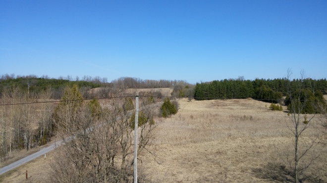
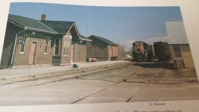
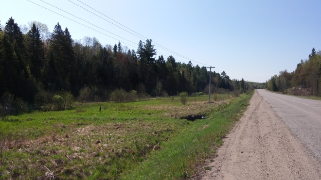
In May 2016, I had the chance to work a teaching contract north of Haliburton. This was also an opportunity to capture some of the railway scenes along the former Haliburton Subdivision between Lindsay and Haliburton. This subdivision was initially constructed as the Lindsay, Fenelon Falls & Ottawa Railway, and since then has been operated by the Victoria, Midland, Grand Trunk, and Canadian National railways. Commodities in the small communities along the line were not as plentiful as initially estimated, and passenger numbers were never high enough to warrant the use of passenger only trains. Instead, mixed trains were used to carry freight and passenger in one train. Traffic continued to decline into the 20th century, and the rails were removed in the 1980’s.
THEN: A Canadian National SW-1200RS and caboose passes the old toolhouse in Cameron while headed north to Fenelon Falls. The short train has just crossed Long Beach Road. The caption of this photo states that the toolshed is the last of six trackside structures that once stood in Cameron. Photo taken by Steve Lucas in February 1980 (Hansen, p.278).NOW: No trackside structures or rails remain in the present day. The rails have been replaced by a multi-purpose trail. The trees and structures of the adjoining properties have begun to encroach onto the former right of way. The village of Cameron remains as a community crossroads and rest stop for people heading up to the cottage. Photo taken in May 2016.THEN: Canadian National RS18 3105 arrives at Fenelon Falls station from the south. The engine is about to pull its train across highway 121 in order to access the north switch for the siding beside it. It will then tend to any needed switching. Photo taken by Keith Hansen in April 1975 (Hansen, p.281).NOW: The Fenelon Falls station still stands today, and numerous renovations have been done to maintain its appearance and integrity. This work included the removal of the brick for board and batten. It houses the Fenelon Station Gallery, where the works of local artists are displayed. The siding and yard in behind the station are now occupied by The Fenelon Area Independent Living Association building. The passing siding in the previous photo passed about where my silver car sits in this photo. Photo taken in May 2016.THEN: Fenelon Falls station as viewed from the south. Canadian National SW-1200RS 1209 sits on the mainline beside the station. The station, while appearing in poor condition, was actually in the process of being renovated in order to be transformed into a business. Whether that original business was the Station Gallery or not is not indicated in the photo caption. A flatbed sits between the switcher and caboose which was not present when it was photographed in Cameron, indicating the car was picked up here at Fenelon Falls. An application had already been made to abandon the Haliburton Subdivision the year this photo was taken. Only a few cars were coming to and from Fenelon Falls each year, with even less heading further along the line to Burnt River and Kinmount. Service to Haliburton had been discontinued by this point in time. Photo taken by Steve Lucas in February 1980 (Hansen, p.283).NOW: South end of the Fenelon Falls station today. This shot highlights the board and batten siding the station wears today. Fenelon Falls lives on today as a popular tourist and cottage destination at the junction of Highways 121 & 8. It is also the junction between the north and central segments of the Victoria Rail Trail Corridor. Photo taken in May 2016.THEN: Canadian National “ten wheeler” 4-6-0 1401 steams north out of Fenelon Falls. The train is about to cross Highway 8, which also goes by Helen Street within the Fenelon town limits. The caption states that the train behind 1401 is mixed train 389. The building at the left of the photo is part of Fenelon Falls Secondary School, and still stands today minus the tower on top. The school’s football field and running track currently sits in the flat area beside the fourth and fifth cars of the train. Photo taken in June 1956, and is part of the Paterson George Collection (Hansen, p.278).NOW: The football field and track dominate the landscape today, leaving little trace of the former railway right of way. It passed to the left of the photo, which can be seen as a grey line outlining the parking lot for the field. The building from the previous photo still stands, however it cannot be seen through the trees. The right of way continues behind my location. It crosses King Street before ending at the Fenelon river swing bridge. Photo taken in May 2016.THEN: A Canadian National baggage car sits with a white PROCOR tanker on the mainline at Fell, about five miles northeast of Fenelon Falls. They are part of a northbound Lindsay-Haliburton train, which the caption indicates has stopped at Fell to drop a car at Shore Gas & Propane. Photo taken by Keith Hansen in December 1973 (Hansen, p.283).NOW: The propane compound at Fell remains today as a Superior Propane depot. Finding the exact location of Keith Hansen’s photo was tricky, and this location was determined the most likely spot. The mainline right of way remains as part of the northern leg of the Victoria Rail Trail Corridor. Any evidence of the access siding for the compound seems to have been removed. Photo taken in May 2016.THEN: Canadian National mixed train 389 stops at the Burnt River station with its rear coach fouling the crossing at Burnt River Road. The caption indicates that this picture documents the final running of mixed train 389, which was the last scheduled passenger train to depart Lindsay for the slow journey to Haliburton. It later returned to Lindsay as mixed train 388. Mixed trains consisting of freight and passenger cars were the primary type of trains operated on the Haliburton Subdivision. This was a result of the low levels of freight and passenger traffic on the subdivision, which wasn’t enough to warrant specific passenger trains. Passenger service on the line was discontinued in 1960, with the exception of the occasional tourist excursion. The freight traffic was replaced by way freights that ran to Haliburton three times a week. Photo taken by Ray Corley in September 1960, and is from the James A. Brown Collection (Hansen, p.286).NOW: Only the right of way remains at this location today. The station was moved to a farmers field to be used as a shed. The name board from the station has been preserved, and is part of a display in the town. Burnt River remains as a small village about halfway between Fenelon Falls and Kinmount. The trail that occupies the right of way is enjoyed by cyclists and outdoor vehicles. Photo taken in May 2016.THEN: After Fenelon Falls, Kinmount was the next major station stop. This photo shows the station that was built to serve the small village in 1876. While it is still standing in great condition, its last passengers had departed it close to fourteen years ago. The track closest to the photographer was the passing siding, while the track closer to the station was the mainline. A second siding passed behind the station, however it had been removed by the time this photo had been taken. Photo taken by Keith Hansen in March 1974 (Hansen, p.288).NOW: A rare instance where the station today is in better condition then the past. The Kinmount station still stands, and currently serves as a tourist information centre. It also serves as a meeting point for many local community organizations. While most of the numerous stations across Canada have been demolished with no regard for historic value, this station was acquired by the neighbouring counties of Victoria and Haliburton with the intention of preservation. They understood that the station serves as a symbol of the railway, which was crucial for the formation and survival of the town, as well as the other small towns along it. It just got placed onto a new frame in 2007, and it looks better then ever! Photo taken in May 2016. The townsite of Kinmount, and the bridge over the Burnt River, can be seen in the background.THEN: Canadian National RS18 3119 arrives at Kinmount from the south. The caption states that it is preparing to drop the gondola car onto the siding. The south siding switch of the siding is visible at the right of the frame beside the end of the train. The roof of Austin’s Sawmill is visible above the first two cars of the train. It was one of numerous sawmills along the Haliburton Subdivision, as well as the nearby Irondale Subdivision. This mill was one of the largest along the line, and contributed carloads of lumber that was moved along the Haliburton Subdivision. It was no longer operational at the time of this photo. Photo taken by Keith Hansen in March 1974 (Hansen, p.288).NOW: While Austin’s Sawmill remains standing today, it is hidden from view in this photo by the tool shed and trees. The exact location of the previous photo is overgrown, making this the closest possible vantage point. Despite not being visible, Austin’s Sawmill has been preserved, and is part of the Austin Sawmill Heritage Park. The Victoria Rail Trail passes in the foreground past the pickup truck. Photo taken in May 2016.THEN: Two Canadian National GMD-1 engines lead a fall excursion train south towards the northern limits of Kinmount. The train had left Toronto for Haliburton via Lindsay, and was on the return leg of its trip. The train had dropped off its passengers in order to do a runpast for photographers. The road in the foreground is Highway 121, while the body of water in the background is the Burnt River. Photo taken by John Vincent in September 1967 (Hansen, p.287).NOW: The increase in foliage and absence of track side structures made finding the exact location very tricky. The only focal points I had to work with were the right of way, and a yellow road sign, which is visible as a small dot at the right of the road where it curves into the trees. I placed the location as being just before Boundary Road. While the Victoria Rail trail terminates at Kinmount, the right of way remains intact between Kinmount and Haliburton as the Haliburton County Rail Trail, and can be navigated by off road vehicles and bicycles. The Burnt River is barely visible by the telephone pole at the right of the photo.. Reaching this location involved climbing the rock wall at the side of the road, which can be seen in the bottom left corner of the photo. Photo taken in May 2016.THEN: While the route of the Haliburton Subdivision passed through rugged landscapes for its entire 55 mile length, these landscapes became increasingly rugged and isolated the closer the rails got to Haliburton. In this photo, a simple wood trestle carries the rails of the Haliburton Subdivison over Milburn Road, a rough gravel track barely wide enough for two cars to pass. The tree covered Haliburton Highlands are visible in the background. This caption states this bridge was built in 1948, and restructured in 1970 due to its deteriorating condition. It had the distinction of being the only grade separation along the entire fifty-five mile long subdivision. All other roads that crossed the line met the rails at a level crossing. Photo taken by Keith Hansen in May of 1970? (no exact date given) (Hansen, p.290).NOW: On the way up to Haliburton, I missed the turn for Milburn Road, and had no time to turn back and find it. While I found it on the way back to Lindsay, I was unable to catch the scene in the daylight. The headlights of my car help to illuminate the location of the bridge, which was torn down when the tracks were removed. The raised embankments on either side of the road are the only evidence that there was ever a grade separation here, as they indicate the approach needed to cross the bridge. Those travelling along the trail from either direction are forced to follow it down a moderate hill to reach the roadway, only to climb an equal sized hill upon crossing to reach the original alignment. Photo taken in May 2016.THEN: SW-1200RS 1243 prepares to make a station stop at Gelert with mixed train 388. The train is headed southbound towards Lindsay. Gelert first sprang up as a village once the old Bobcaygeon Road was build in the 1800s. The town boomed upon the arrival of the railway, and it served as a major shipping point for lumber and farming goods. Gelert was also where the rails passed the closest to nearby Minden, and daily stagecoach trips operated between the two villages. This connection caused Gelert to be briefly named “Minden Station”. Over time the farms became less prosperous and the lumber supplies ran out. The siding was eventually removed, and only the occasional passenger passed through the station. Once the railway was removed, Gelert became a partial ghost town. Photo taken by R.J. Sandusky in October 1959 (Hansen, p.290).NOW: The townsite of Gelert remains as a partial ghost town. It is located on Gelert Road (County Road 1) which runs between Highway 121 and Haliburton. The station site can be accessed via Cemetery Road, which crosses through the photo. The station stood at the grassy area at the right. No evidence remains of the station, sidings, or any of the former trackside structures. Only the path of the mainline remains as a dirt trail. North of the station, the tracks swung east and crossed the Drag River on a “pony truss” bridge. The bridge remains today, and is crossed by snowmobiles and all terrain vehicle instead of trainsTHEN: Canadian National RS-18 3107 busts through snow drifts just north of Donald while enroute to Haliburton. Donald is a tiny hamlet just outside of Haliburton. In the early 1900s it was also the site of the Standard Chemical Company. The company employed hundreds of workers, many of whom lived year round at the compound. This site created lots of outbound traffic on the Haliburton Subdivision, as well as inbound materials for the company’s operation. It was also a shipping point for lumber and forest products, which were plentiful in this region. Standard Chemical closed in 1945, and freight traffic diminished to nothing. Photo taken by Keith Hansen in December 1972 (Hansen, p.292).NOW: Going to and from Donald, Gelert Road follows the route of the Haliburton Subdivision right of way. The lack of focal points in the previous photo make finding the exact location slightly tricky. The only hint provided was in the caption, which stated that the photo was taken approximately one mile north of Donald. Once I reached Donald, I used my odometer to track mileage, and pulled over once I reached approximately one mile. Two of the tall trees in the background look similar to the tall trees in the previous photo. The wide open space between the tracks and the road is also similar to the space found in the previous photo. Photo taken in May 2016. NOTE** Looking at the two photos now, I notice that it appears Keith is looking slightly downward in his photo. A small mound is visible in my photo, leading me to wonder if maybe that mound is the exact location of Keith’s photo.THEN: Canadian National RS-18 3107 sits at the edge of the Highway 21 crossing at the edge of Haliburton. A build up of ice and snow between the flangeways at the road crossing caused the engine to derail slightly from the tracks. In this photo, the engine has been re-railed, and crews are working to clear the tracks. This train is the same one photographed at Fell and Donald. Photo taken by Keith Hansen in December 1972 (Hansen, p.294).NOW: 3107, the rails, and the snow are all absent in this photo. Highway 21 remains, and it meets Gelert Road at this intersection. Haliburton Highlands Secondary School is visible in the background, as is Head Lake Park. Here, an Avro Canada CR-100 Canuck fighter jet and Canadian National 2-8-0 Consolidation 2616 are on static display. 2616 operated trains to and from Lindsay during the era of steam, and was donated to the park in 1960. Photo taken in May 2016.THEN: Canadian National RS-18 3119 is busy organizing its train in the Haliburton yard. The caption states it is in the process of dropping a small cut of cars in front of the Haliburton station, which is just visible beside 3119. Passengers no longer passed through the station, with the exception of occasional excursion trains, and it was currently serving as a freight depot. A flanger caboose is visible on the left-most track. After dropping the inbound cars, the train would assemble the outbound cars and head south to Lindsay. Photo taken by Keith Hansen in Mach 1974 (Hansen, p.294).NOW: The station grounds have undergone a massive transformation since 1974. The tracks, railway buildings, and lumber yards have all been removed. In its place stands park land and parking lots. The station remains, and it is visible in the middle of the photo. It is currently home to the Rails End Gallery & Arts Centre. Canadian National caboose 77127 and a CN boxcar are on display near the station. The orange caboose is clearly visible in this photo, while the brown box car is barely visible between some trees to the right of the station. Photo taken in May 2016.THEN: The Haliburton station is shown more clearly in this second photo of the Haliburton rail yard. A Canadian National boxcar and express coach sit on the loading track beside the station. A Canadian National caboose sits on a neighboring track at the right of the photo. Diagrams of the yard show the two tracks curving to the left of the photo continuing across the Drag River to a point just east of Maple Avenue (Highway 118). The “express freight” sign on the side of the station displays its new role. Photo taken by Keith Hansen in March 1974 (Hansen, p.295).NOW: The Haliburton station remains in excellent condition, and much work has gone into its preservation. The rail yards are now a public park with many walking trails. One of these trails follows the right of way alongside Head Lake to where the tracks crossed Highway 21.
I hope you enjoyed viewing my photos, and comparing them with past railway scenes taken by noted railway photographers. As cool as it was to find these locations in present time, it was sad to see how much has been removed, overgrown, or built up. The railway was vital to the creation of the numerous small towns and villages in Central Ontario. Despite this, most of the tracks have been removed, and only a handful of the trackside structures remain. However, as you have seen in these photos, if you know where to look, you can find lots of hidden remnants.
Thank you for taking the time to view this project. The idea of creating this side by side project has been on my mind for many years, and I am glad to have finally gone ahead and completed it despite work and other commitments slowing me up. If you have any comments, questions, or concerns, feel free to contact me or leave a comment on this page.
Lastly there may still be some more additions in the future. Despite documenting many of the lines that passed through Lindsay, I did not get them all. I have no photos of the Midland Subdivision between Midland and the Lindsay town limits. I also have no photos of the Canadian Pacific Bobcaygeon Subdivision outside of the Lindsay town limits, and the former Coboconk Subdivision between Blackwater and Woodville. All of these locations are documented in Last Trains From Lindsay, and it would be nice to get some comparison shots from those locations. I will attempt to shoot some of these locations the next time I am up that way, so stay tuned for more additions.